Narrative of an expedition to Furneauxs Islands on the coast of New South Wales, in the Port-Jackson colonial schooner Francis.
By Mattw. Flinders
2 lieutenant of H.M.S. Reliance March 1798
The ship Sydney Cove, from Bengal to Port Jackson, having been wrecked on one of Furneauxs Islands, the colonial schooner Francis, and a small sloop in which was Mr A. Armstrong—master of H.M.S. Supply, went from Port Jackson to fetch away part of the people and cargo. The schooner returned safe, but the sloop has not yet been heard of. In the beginning of February 1798, the schooner went a second time, to bring away the rest of the people, and every thing valuable that remained.
On this occasion, the writer of this narrative obtained the permission of His Excellency governor Hunter to accompany Mr Hamilton —commander of the wrecked ship, for the purpose of making such observations, serviceable to geography and navigation, as circumstances might permit; and the master of the schooner was ordered to assist in forwarding those views; as also, to endeavour to find a small island somewhere to the southwestward of Point Hicks, where some convicts had been left by a boat, which they and others had ran away with from Port Jackson.
1798
February On Thursday 1st at noon, passed between the heads with a moderate breeze at N-N-E. At sunset, the northern Hat Hill bore W[by]N
∗ six or seven leagues. On the following
Friday 2 noon, the land bore south-southwest to north-north-west through the haze, five or six leagues distant, being irregular and high. The wind was in light airs from the southward, and the latitude observed 35° 42′ south.
Standing in shore, we made some small lumps of land, which, at seven in the evening, bore S-¼-W three quarters of a mile; and proved to be two rocky islaets about a cable's length asunder, but connected or nearly so, by a reef: a smaller, low island was shut on at the back in this direction, about one mile distant. In this situation we had eight-and-half fathoms, and standing in towards Bateman Bay, the water shoaled to seven and six fathoms, when we tacked and stood out; a steep head, which was taken for Point Upright, then bearing N-E, with a small rocky island or rocks lying off it. The first islands appeared to us to lie about two miles off the south head of the bay; but the weather was too hazy to distinguish anything clearly.
Saturday 3 At eight A.M. the low island bore N-W two or three miles. We were then standing to the southward, with a light breeze at N-N-E, and when abreast of the outermost projecting point, and three-quarters of a mile distant, sounded in twenty-one fathoms. From this point, the land lies S-W-½-S; and towards Bateman Bay about N-N-W. At five miles from the point, we saw the appearance of an opening, whose heads shut on at W-b-S; the entrance being from the north-east and apparently about half a mile wide. From the distance of the high land within, which seemed to leave a large vacant space forming like a basin, we judged there might be a good harbour in here. It is about seven miles south of Bateman Bay, and therefore should be in 35° 43′ south. At noon, the east point bore north-by-west six or seven miles, but the weather being hazy, we got no observation for the latitude.
5
6
Steering south-south-east with a fresh northeasterly sea breeze, we soon after made land on the weather bow, which proved to be an island one mile and a quarter long, north and south; but nearly divided into two parts, the sea appearing to break over the isthmus at times.
We were surprised to find an island lying near two leagues off the coast; none being noticed by captain Cook, who passed this part on a fine morning, as appears by his getting lunar observations; which circumstances indeed, from engaging his attention, might have been the reason he did not see it. From the number of seals about, we termed it Seal Island. It is rocky, but has brush and trees upon it, and is not very low. We saw no beach, or other place, where a boat might land, except in very fine weather, and there are breakers off the south-west end. By our run from Bateman Bay it should be in about 35° 59′ south.
Sunday 4 At half past five on the following morning, we were about two miles from the shore, and abreast of a projecting head, where we go no ground with thirty fathoms; and when a green cape, which we took for Cape Howe, bore south-half-west five miles, had no soundings with thirty-five fathoms. When the cape bore W-b-S or true west, had none with twenty-five fathoms, though only one mile and a quarter from the shore. From the projecting head, the coast is straight and rocky; not high, but thickly covered with trees until within two miles of the cape. It is there well clothed with grass, appearing very smooth, and sloping to the point, which is rather low. The line of the coast is S-S-E-½-E, but directly round this green cape, it runs in west two-and-half miles to a sandy beach: breakers extend about a cables length off the pitch of the cape.
At noon, a sandy point bore south about six miles, and the green cape north three or four leagues, when our latitude observed was 37° 25′ south, which is only one mile from captain Cook's situation of Cape Howe; we were therefore in doubt which of these two was the cape; but captain Cooks direction to know it, being the trending of the land to the south west on one side, and north on the other, shows that the sandy point was Cape Howe: its latitude must be about 37° 31′; and this is the situation I afterwards found Mr Bass made it to be in, by an observation due west from it.
Standing along at the distance of one mile and a half from the shore, we observed some fires, and counted seven natives upon an eminence, looking at us. At this time, the wind chopped round to south-by-west, and began to freshen, with thick weather; which obliged us to leave the coast. At two o'clock, we took our departure from Cape Howe, bearing west-by-south three miles, and immediately lost sight of the land. The wind came to the south-east at midnight, when we tacked in shore, wishing to keep it on board that we might not pass the island upon which the convicts were; supposing it to be not far beyond Point Hicks.
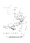
Monday 5 On Monday at noon, we found ourselves 38′ to the south of the reckoning, when we bore away west, and ran seventy-four miles to the next noon; our latitude then, Tuesday, 6, by double altitudes, was 38° 16′ south, and the dead reckoning longitude 22′ west of Point Hicks. At half past three, we kept more away, and soon after made a moderately high sloping hill, and other land to windward and leeward. At sunset, a low flat point (marked a in the sketch) bore N-W-b-W-½-W three or four leagues; at which time we hauled to the wind, it being still southerly in light airs.
Wednesday 7 At daylight, the flat point bore N-N-E-¼-E six or seven miles; at the same time a meridional altitude of the moon gave the latitude 37° 48′ south; and some distances of Antares east of the moon, reduced to our situation at six o'clock, when altitudes were taken for the apparent time, gave the longitude 147° 41′ east, which is to the north and west of Point Hicks.
We made sail with a moderate north-easterly breeze along the coast, which is low and woody, and faced by a continued beach as far as could be discerned to the southward; our distance, in general, was from four to six miles. Before ten, I got other altitudes, and two sets of distances of the sun east of the moon, which agreed very nearly with the former. The mean of the whole, when reduced to noon, was 147° 13′ east of Greenwich; and the observed latitude at that time was 38° 17′ south. The shore was distant six or seven miles, continuing in nearly a straight line as before, and with a range of hills four or five leagues inland.
7
At two in the afternoon, we struck a sandy bottom with eleven fathoms, being then but two-and-half miles from the land; but about four, the sea breeze coming more on the shore, and freshening instead of abating, contrary to our expectations and its usual routine, it obliged us to haul off south, south-south-east and south-east-by-south, which was as near the wind as the schooner could make any way, with the sea that had now got up. The shore was still low and sandy as far as we could see, with two or three openings in it, the farthest of which bounded our view at three or four leagues distance: the weather being now thick and hazy. At sunset, we could distinguish a remarkable mountain to the south-west, which appeared as if cut in two and the parts removed to some distance from each other.
Supposing we must have now passed the island which we were in search of, and finding the coast to be so dangerous with an easterly wind; all hopes of finding the people were given up, in favour of making the best of our way to the south-eastward for Preservation Island, as the wind might permit.
Thursday 8 At daylight, there was a good deal of sea running, but the weather was fine, with a light breeze from the east-by-north. Land appeared soon after on the weather and lee bows. That to windward was high and steep, consisting of irregular lumps of land, which at first made as one island; but in running past, two smaller ones divided from the north-west end, and presently an opening appeared in the main body
∗ of three-quarters of a mile wide, seemingly deep and clear; indeed the water every where was very blue: we tried the soundings with twenty fathoms but got no ground. The land to leeward consisted of two small islands and two rocks; the largest of the rocks, from its peculiar form, we called Judgement Rock. The sketch will give the best idea of their relative situations and extent.
At noon, our observed latitude was 39° 38′ south, the passage through the large island bearing north-half-east about five miles,
† and the largest of those we passed to leeward northwest-by-west two or three leagues. About one, we found ourselves set considerably to the westward, as in the morning we had to the eastward; so much so, that by steering south-east-by-south we came up, at four o'clock, with a small, rocky, ragged, pyramidal-shaped island, which at two, had born south-quarterwest seven or eight miles. There is a chasm in this pyramid, through which the daylight appears when bearing about west-north-west. We passed one mile to windward of it, and saw a reef running three-quarters of a mile out from its south end.
At six, we saw land bearing E-b-N-½-N, and thence to E-¼1/4-N, appearing to be the south end of an island and about five leagues distant. The south extreme of another range of hills bore south-east-by-east six or seven leagues.
The wind still continued from the eastward, but soon after came round from the north and north-north-west. At eleven, we found ourselves within a mile of a low island or point, and about the same time it fell calm, and remained so till four in the morning; during which, we were set four or five miles to the westward. Friday 9. At daylight, the low point bore south-east-three quarters-east six or seven miles, and now proved to be part of the land set the preceding evening, which at this time was judged to be one very large island, extending from south-three quarters-east about five leagues, to north-east-quarter-north three leagues: our distance from the shore was not more than three-and-half miles. An island, moderately high, lies one mile and a half from the north end, within which we proposed to pass, and made sail accordingly with a breeze from the south west. A high, ragged island of about two miles in length, bore north-three quarters-west eight or nine miles, with a rock lying nearly half a mile off the east end of it.
The large island is moderately high, irregular, and seems composed of rocks and sand, though in most places it is covered with brush. When entering the channel, we found breakers running nearly across, close to us; and, although it was not quite certain that the tide was not the occasion of it; yet, as being the safest, we stood round the island; which
8
appeared, like the large one, to be rocks and sand; as was another of nearly the same size, which we likewise passed without, on seeing a rock, with breakers round it, lying in the channel. Having cleared these islands (to the northward of which no land was visible), we stood to the southward along an extensive beach of the large island, at the distance of four or five miles. This island extended as far as we could see to the southward, and from its magnitude, we now began to consider it as part of the main.
At ten, two pyramids appeared in the south-south-east, which were soon after found to be connected with the large island; an island lying off them, has also a pyramid upon it at its south-west end, and between these we kept away to pass; but seeing the low sandy beach running nearly across to the island, we steered to go round all. Our latitude at noon was 39° 50′ 20″ south, the pyramid on the island bearing south-east-quarter-south three or four leagues, and the northernmost of the two islands we passed in the morning, and which I suppose to be the Sisters of captain Furneaux, bore north-west-half-north five leagues.
The wind now blew fresh from west-south-west, with hazy weather; there were great numbers of shags about the vessel, some of which attempted to alight on the masts and yards; the sheerwaters or Mount-Pitt birds, which were also numerous, seemed, as well as the shags, to belong to the pyramid island, for on a nearer approach, we saw it covered with the tufts of wiry grass, under which the latter usually make their holes. This island is between two and three miles long, and presents an appearance not much unlike the lions head and rump, when sailing into Table Bay. There are two small islets divided from it, by channels of one and two cables lengths wide: the latter appeared deep.
Having passed this small cluster, we hauled to the wind round them at two o'clock, and saw high land extending from the large island to south-by-east-quarter-east, which afterwards proved to be Cape Barren. At this time the weather becoming thick, and the wind having shifted to the south in squalls, we lost sight of the land; but at sunset, got a transient view of the island at west-south-west, three or four leagues distant.
Saturday 10 At daylight, we steered to the southward for Cape Barren; and at noon, the observed latitude was 40° 3′ 20″ south; and two sets of lunars, by the sun east of the moon, taken at one o'clock, gave the longitude at this time 148° 1′ east, which was only 9′ west of those taken on the 7th, brought forward by log without any correction; so that though the tides may run strong amongst these islands, and we saw evidently that they did so, yet the flood and ebb must be nearly of equal strength and continuance. Neither have we found any material difference of latitude since the 5th, 9° having been the greatest in any one day, which it is not necessary to have recourse to a current to account for. Our bearings at noon, were,—the pyramid island west-quarter-north three or four leagues;—Cape Barren south-by-west;—an island with a sloping round hill upon it, south-west-three-quarters-south.
Standing on, with a moderate northerly breeze and fine weather, we found that Cape Barren was divided from the large island by a strait seemingly of three or four miles wide; and that the sloping island was situated in nearly the middle of it; but there appeared to be a sufficient passage through.
At half past four, the island we had passed bore north-west-half-north, the pyramid seeming to be distinct from the rest of the land; and the two pyramids on the large island now appeared to be three distinct ones, and not unlike each other in form, the middle one being rather the smallest. As we judged them sufficiently old to deserve the title, I called them the Patriarchs.
Some distant land appeared through the before-mentioned channel between Cape Barren and the large island; and a remarkable round hill bore true west, over the extreme of a projecting point, which seems to be the northernmost part of Cape-Barren Island. From the high land of the cape itself the low extreme runs out to the eastward a mile or two; and off it is a small flat island, connected by a reef with a pointed rock above water, a quarter of a mile east-south-east of the islet. On this rock the sea broke with great violence: between the islet and the cape the channel seemed deep. Captain Furneaux noticed this small island and rock, and it was probably these breakers that induced him to denominate the space off the east side of these islands, the Bay of Shoals.
9
10
At a quarter past six in the evening, we hauled south-west close round the rock. At 8, when off a rocky point, on which are two eminences of white stone in the form of oblique cones inclining inwards, we stood to the southward, and off and on during the night, keeping the peak and high land of Cape Barren in sight: the wind from the westward.
Sunday 11 At the following noon, the observed latitude was 40° 41 ½′, Cape Barren bearing north-by-west. The wind being strong at west-south-west, we continued standing off and on, and lying to occasionally, till day light next morning, Monday 12, when we made sail west-north-west for the south end of Clarkes Island, having the wind now at north-by-east. A little to the westward of the rocky point, which has the inclining cones upon it, lies an island, between which and the point, is a deep channel of between half and three-quarters of a mile wide; and about the same distance to the westward of this island, is another of nearly the same size: they are rather low and covered with brush and grass. Between these islands and Clarkes Island, we observed two low islets, and two rocks above water, the latter not more than three or four miles from us. To the southward also, we saw the land extending a great distance; but the whole are better seen in the sketch.
About ten o'clock, the ebb tide was running with such violence, that although the schooner was going one knot and a half through the water, yet by the land we were evidently going retrograde almost as much, and towards the land withal; but the light air that remained enabled us to draw the vessel clear. When the south point of Clarkes Island bore north-east-by-east-half-east one mile and a quarter, we sounded with eighteen fathoms, but got no ground; and in nearly the same situation, the suns altitude measured from the south at noon, gave the latitude 40° 36′ south. A breeze springing up from the westward, and having the tide in our favour soon after, we got to an anchor the same evening in Hamiltons Road, about a quarter of a mile from the sandy beach on the east end of Preservation Island, in four-and-half fathoms, sandy bottom.
Saturday 17 Until Saturday in the afternoon, the blowing weather and the repairs of the boat, prevented me from doing more than measuring a base line round the north-east end of Preservation Island, and taking the bearings of the most conspicuous places from different parts of it; but the wind being then moderate, and the sea a good deal gone down, I went with the schooners boat and four people, into the channel between Cape-Barren and Clarke Islands, by which Mr Armstrong had before come to Preservation Island. The weather continuing very fine, we crossed occasionally from one side to the other, taking angles on the most projecting eminences; and on the north-east low sandy point of Clarkes Island, with a two miles horizon, found the latitude to be 40° 29′ south. From thence we passed over to the shore under the high land of Cape Barren, the peak of which I proposed to ascend, promising myself a fine view from thence, of the north side of the island — the channel between it and the large island — and also of the southern land, whose connexion with the main coast of Van Diemens Land I was anxious to ascertain. But though its height did not seem to preclude the attempt, yet the thickness of the brush made it apparent, that the labour of a few hours or perhaps a day would not be sufficient to accomplish it carrying the instruments, without which our going up would have been of little service.
Having taken angles at two stations on that shore, we passed round to the rocky point which has the two conic eminences upon it, through the channel by the north-east end of the two islands.
∗∗ We met the flood tide here: and although it had made little more than an hour, and the boat was going with as much wind on the quarter as could be of any service, yet, in particular parts, it was only by the nicest steerage that we could make head way: its rate must have been more than four knots.
11
On the smooth, sloping parts of Rocky Point, there were many seals, most of whom precipitated themselves into the water as we rowed by. We had before killed several, particularly on a small barren island near the center of Armstrongs Channel, which, from the similitude of four rocks upon it to mounted guns well elevated, is called Battery Island; but on this point the numbers exceeded what we had before met with. The terrors of the young cubs who had not yet dared to take the water, afforded us a good deal of amusement; they huddled in together among the rocks, putting up a dozen noses through the cavities, and expressing their fears of their tormenters by piteous looks and moans. One of the elder would sometimes assume courage enough to bark in a tremulous tone, and indeed became very fierce on our walking away from them. We killed as many large ones as there was time to skin whilst taking the bearings, and then ran to the south end of the easternmost of the two islands, on our way back. I much wished to have gone round the island of Cape Barren, and so have returned by the west end of it to Preservation Island; but our situation in point of time, made it necessary to return by the nearest way.
The two conic-formed eminences on Rocky Point, are of the same stone which seems to compose the beds of all these islands, and is a solid, white granite, with small black specks in it; and the uncovered patches about the peak and other parts of the high land, make it probable, that they are likewise vast bodies of a like substance. It was in few places that any other kind of stone was met with; some black and grey slate were almost the only exceptions. These were universally placed in thin strata, whose position was perpendicular or nearly so; but between the strata, the granite in general had insinuated itself; and in two instances a kind of hard, speckled substance, which may probably be what is called the toad stone. From the manner in which these had inserted themselves, it could have been done only when in a liquid state. Granite being the heaviest of all stones, must, according to geologists, have been placed nearer than any other to the center of the earth, in its primitive state; and being situate so near the fountain of heat and fire, might be dissolved, when the more light bodies, such as slate, were not, or perhaps could not. When the universal burst happened, which some suppose to have taken place in consequence of the sudden rarefaction of the air and water, which had gained admission to this internal region of fire, these bodies might naturally become thus compounded; the liquid substance filling up every interstice, which its fluidity and superior gravity enabed it to penetrate.
On the two islands, there were plenty of seals, Mount-Pitt birds and penguins, for our purpose; but it required a good deal of search to obtain a sufficiency of brackish water. We were detained one day on the western island by a gale of wind from the south-east, and being on the south-east side when it came on, it was with risk we got round to a place of safety. In these passages I had no opportunity of sounding; for, having carried away the step of the boats mast, we were obliged to use the lead line as shrouds to support it; but the breakers and shoal water, as far as we could see them, are marked in the sketch. We stopped at the south-east end of Clarkes Island and took angles as before, as also from a high rock on the south-west end. From this eminence, the southern land seemed to be very extensive. To the westward, there were some small patches of land like islands; and the same conspicuous round hill, (Mount Chappelle) which had born due west through the channel, now shewed itself on the land at the back of them, which likewise only appeared at intervals. Was it not for the remarkable distinction of having seen no fire or smoke upon the large island, and the contrary on the southern land; I should have thought it probable, that they joined at a greater distance, forming a deep sound. It may be observed that we saw no fires or smoke, or traces of any but what we could account for on any of the islands, from the long beach to this southern land; it is therefore probable, that the islands are uninhabited; and the seals, Mount-Pitt birds, penguins and geese, by which they are frequented, seems to indicate, that they have been seldom or never visited. Neither did we find ten square feet of ground fit for cultivation on any that we landed upon; they are beds of granite, mostly covered with sand,
12
which, in general, is overrun with inpenetrable brush; and its depressed, creeping form, on the parts exposed to the southward and westward, sufficiently indicates the violence and generality of the winds from those quarters, at some times of the year.
On Wednesday afternoon of the 22nd, we returned on board the schooner, which was nearly ready to sail, having received the greatest part of her cargo; but the wind continued north-easterly till the 25th. During this time, I went round Preservation and Rum Islands, got bearings from the principal projections and eminences, as also from two on the opposite shore of Cape Barren. The altitude of the suns upper limb, measured from the southward, on the south side of Rum Island, gave 40° 28′ 20″ south, which differs something from the two observations taken on and near to places connected by the survey. In placing them in the sketch, a mean is struck betwixt them, giving to each the weight which their separate goodness appeared to deserve.
The wild geese were more numerous on Preservation Island, than on any other that we landed upon: they were always shy. The kanguroo seems to abound on Cape Barren and Clarke Islands, as well as on Preservation Island; and on the two former, those remarkable badger-like animals are equally numerous; but in most places, from the thickness of the brush, it is impossible to pursue either of them.
A peculiar transformation seems to take place in a part of the trees of Preservation Island. The biggest of these were not thicker than a mans leg, and the whole of them were decayed; but whilst in some cases, the branches continued to be of wood, the trunk was of a white stony substance something like chalk, and sometimes composed of both: the petrefaction appearing to commence at the root and proceed upwards. The situation in which these are principally found, is a sandy valley in near the middle of the island; which is likewise remarkable by being thickly strewed with the bones of birds and small animals. How these bones came there, can only at present be conjectured; and to what depth they may extend, we did not examine. It might be worth the investigation to inquire, whether any latent connexion could possibly exist, between these animal substances and the transformation observable in the trees.
At the tops of many of the large lumps of rock, particularly on Rum Island, is a hollow, in which a smaller stone rests, as a cup in its sawcer; and when under the high land of Cape Barren, I observed, with a glass, the same thing at the summit of the peak.
Hamiltons Road seems to be the only place for a vessel of any size to ride in; one that did not draw more than seven or eight feet water, might go into either of the bays round the north-east point of the island. There are indeed several places between Cape-Barren Island and those south of it, where a ship might ride in security, over a sandy bottom of sufficient depth; and if ever examined, there will no doubt be found passages into them. According to Mr Hamilton, the tide flows into the road till half past eleven o'clock, at full and change of the moon: at Port Jackson it is high water at half past eight: the flood therefore, comes from the northward on this part of the coast.
Sunday 25 At nine in the morning, we got under weigh, having a strong westerly wind; and weathering Clarkes Island, stood on to the southward, the master of the schooner having agreed to take a look at the southern land. At noon, our observed latitude was 40° 44 ½′ south, the largest Swan Island bearing N 76° to S 82° W, with a small one shut on at the back; and the peak of Cape Barren N-5°-E.
We continued steering south-south east, with an ebb tide, until I judged our latitude to be 40° 50′ and then wore to the north-east. In this latitude captain Furneaux says, the land trends to the westward; and having laid down a continued coast from the south end of the country to this latitude, there can be no doubt but that the shore in sight of Preservation Island is a part of Van Diemens Land; and as we have great reason to believe, that the whole of the land at present known, between it and the long beach is uninhabited; the probability is, that it is unconnected with either of them; and that this coast of Van Diemens Land, and the before-mentioned long beach, may be the sides of a strait, dividing New South Wales from Van Diemens Land; but the reasons that Mr
13
Bass saw for the same opinion, seem to put it almost past conjecture.
When we wore to the north-east, the south extreme of the main bore south-south-east four or five leagues, and the island N 52° to 70° W two or three leagues: our distance from the main being four or five miles. Near the shore, the land is not high or uneven, but four or five leagues inland, there are irregular mountains which run to the southward as far as we could distinguish. The coast is tolerably straight, with long sandy beaches, and stony heads, at intervals. According to the report of the man left on Preservation Island with the Sydney Coves cargo, the Swan Isles abound with geese and swans, which come there to lay in the spring; at which time, the ground is all over strewed with their eggs. This report induced me to give them the name by which they are at present distinguished.
At four in the afternoon, the true bearing of Cape Barren was N 10° W distant nine miles; and two sets of distances of the sun west of the moon then gave 148° 5′ 19″ east; whence the longitude of the cape should be 148° 48′ 14″; but the two sets of the sun east of the moon, taken likewise in sight of it on the 11th. place it in 147° 51′ 40″; the mean is 148° 19′ 57″, being about 12′ east of its situation in captain Furneaux's chart. But even if 28′, half the difference of the observations on opposite sides of the moon, be applied to the lunars taken near the land called Point Hicks, as the error of the eye and in the parallelism of the direct shade glasses, they will still be 1° 2′ west of captain Cook's longitude. Which of these two navigators are right, I will not pretend to determine. In the sketch, the longitude of each is marked, and my observations noted in the situations they were taken; leaving any person who may visit those places, to follow that authority he may think most deserving of credit.
The variation of the compass allowed is 12° east: captain Cook having found it to decrease something in running to the northward, and at Port Jackson it is 11° at present. We had no azimuth compass on board the schooner, to try the variation by; and while on shore, I had little time to get observations by the theodolite, and but few opportunities. There will no doubt be several errors in that part of the sketch made on board the schooner, arising from the badness of the compasses, in part; but perhaps still more so from the tides rendering a base very erroneous, if run during any smaller interval than a whole tide; and these will be principally in longitude, on account of the direction of the coasts, consequently of the tides; and also, that having no time-keeper, observations to correct the dead reckoning could not be made so often, or with anything near the accuracy, that they were for the latitude.
We saw no land after leaving Cape Barren, till we made the northern Hat Hill on the 7th of March. On the 9th we arrived at Port Jackson.
Note. The data and results of the most material astronomical observations, will be found in a table at the end of the narrative of a future voyage to these parts, in the colonial sloop Norfolk. The observations of both voyages are combined in that table.
See Notes, pp. 20–21, and E. Scott, The Life of Captain Matthew Flinders (Sydney, 1914), ch. 8, for the circumstances of the expedition.
The Narrative of an expedition to Furneauxs Islands has previously been published in a limited Golden Cockerel edition, edited by Geoffrey Rawson (1946). The work is extremely rare.
Several inaccuracies in Rawson's transcription have been corrected. We have followed Rawson's practice of italicising ships’ names and introducing hyphens instead of stops for N-N-E, etc. We have also amended, here and there, the precise placing of the dates of the journal entries, and have eliminated one repeated word. Otherwise, the text has been faithfully followed.
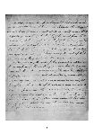
Ernest Scott remarks: ‘It is a beautiful manuscript, 22 quarto pages, neat and regular, every letter perfect, every comma and semi-colon in place: a portrait in calligraphy of its author.

 [map]")