The Navigational Records of the Burke and Wills Expedition in the State Library of Victoria
The Australian Manuscripts Collection at the State Library of Victoria is often visited or contacted by prospective outback travellers planning to retrace the steps of Burke and Wills. They frequently expect to find, in the papers of the Expedition held by the Library, a clear and simple guide to the route taken by the explorers, but are confronted instead by a mass of material — notebooks, astronomical observations, journals, maps — which is reluctant to yield its secrets to any but the most determined researcher.
The purpose of this article is to give a brief account of the existing navigational records of the Expedition, and to provide researchers with an idea of what they can reasonably expect to find therein. It confines itself to that part of the Expedition of most interest to modern researchers, i.e., Burke's ill-conceived “dash” from the base camp at Cooper's Creek to the Gulf of Carpentaria and back during the height of the summer of 1860–61.
Perhaps it is best to begin with two blunt facts about these records. They are incomplete and, to some extent, they are unreliable. Anyone hoping to “trace the footsteps” of Burke and Wills must resign themselves to acquiring, at best, an approximate idea of the whereabouts of these explorers: “small” errors and discrepancies in navigational calculations quickly turn into miles when one is on the ground itself.
Wills as navigator
As Surveyor, William John Wills had the responsibility of recording the route taken by the Expedition, and determining the party's position when required. The two principal techniques available to him were astronomical navigation and “dead reckoning”, also known respectively as navigation by observation and by account. Astronomical navigation involves observing the elevation of certain heavenly bodies above the horizon at precise times. The navigator then performs a complex series of calculations (“reduction”) using current data about the heavens — in Wills' day this was provided by the annual Nautical almanac — to derive a reading of latitude and longitude. The success of this method obviously depends on the accuracy of one's timepiece and of the Nautical almanac.
Dead reckoning begins with a known latitude and longitude: the navigator keeps a detailed log of distances travelled and the compass bearing of each stage of his journey. These are plotted onto a chart and a new latitude and longitude can then be read off. This method relies on the accuracy of one's compass and of one's measure of the distances traversed. Local variations in the Earth's magnetic field, which are not uncommon, can cause compass errors which will obviously be magnified the further one travels.
1In drafting their instructions to Wills (Appendix A), the Exploration Committee of the Royal Society of Victoria recognized that he might seldom have time to make the long and complicated calculation necessary to convert astronomical readings into latitudes and longitudes: he was to do so whenever he had the opportunity, but a complete analysis could, if necessary, await the Expedition's return.
15
Wills kept basically four kinds of record: meteorological readings, astronomical observations for the purposes of navigation, a written journal, and a log of each day's journey showing times, compass bearings, distances and geographical features. (The term “fieldbook” was used fairly indiscriminately for all of these). The State Library's holdings of these records are by no means exhaustive, i.e., we do not hold each kind of record for every part of the journey.
Gaps in the record
The most notable gap is that there are no surviving astronomical observations for the journey from Cooper's Creek to Carpentaria. Wills must have made these observations, because we know that he produced a map
giving latitudes and longitudes of the camps along this route, and because each of his field books for this part of the journey states the range of latitude traversed therein.
Wills' fieldbooks for this leg of the journey are a general verbal account of the Expedition's progress: references to distance and direction are approximate, and the most common points of orientation are creeks and other impermanent bodies of water. By themselves they are unlikely to provide sufficient information for anyone wishing to reconstruct the route taken.
2We possess Wills' astronomical observations for the return to Cooper's Creek, which are almost solely readings for latitude.
3 The Government astronomer Robert Ellery, when
16
he came to report on Wills' records (see below and Appendix B) noted that Wills had made longitude readings for only four camps on the return. This omission is understandable when we consider that the explorers knew they were travelling, as nearly as possible, due South along the 140th meridian of longitude, and that the Expedition had by this stage been reduced to a desperate race for survival.
Wills' fieldbooks for the return contain, if anything, even less navigational information than their counterparts of the Northbound journey. Not surprisingly, his map only intermittently plots the return. Around 3 April 1861, the explorers discarded everything but their few remaining supplies, so no further observations could be made.
Mr Wills' map
Amongst the papers retrieved after the end of the Expedition was a map of the route, prepared by Wills. Ellery's report, and the minutes of the Exploration Committee for 6 November 1861
4 refer to it, and a lithographed copy was produced by the Office of Lands and Survey, Melbourne, in November 1861. The whereabouts of the original are today unknown.
The published map comes closest to providing the kind of guide so eagerly sought by Expedition enthusiasts.
5 Anyone wishing to use it as such must do so with an awareness of its shortcomings: (1) because the original is almost certainly lost, we cannot assess the accuracy of the printed copy; (2) because we do not possess Wills' astronomical data for the Northward leg of the journey, we cannot verify the accuracy of his reductions; (3) where we do possess his astronomical data (i.e., on the return leg) these have been found to be not entirely consistent with the positions plotted on the map (see next section).
Mr Ellery's report
The Victorian Government Astronomer, Robert Ellery, prepared a brief report on “Mr Wills' astronomical observations on his return from Carpentaria to Cooper's Creek”.
6 He compared Wills' readings for latitude and longitude with the positions plotted on his map, and found that while the latitudes corresponded fairly well, there were discrepancies between the longitudes he derived from Wills' observations, and the longitudes Wills himself had plotted. He concluded that Wills had plotted his latitudes from the results of astronomical observation, but had plotted his longitudes by the less reliable method of dead reckoning.
Ellery also provided corrections for reductions Wills had made on the basis of erroneous data in the Nautical almanac. These were incorporated in the printed version of Wills' map.
Modern travellers have had only limited success in tracing the route of the original expedition. A party led by Mr Chris Tangey in 1995, which had made a close study of the Burke and Wills papers and which had access to astronomical and surveying expertise, was only able to identify approximate areas in which to search for traces of the explorers: no conclusive finds of Expedition debris or jetsam were made.
7
The dispersal of original
Expedition records
When the papers of the Expedition were recovered in 1861, the Royal Society's Exploration Committee promptly prepared transcriptions of some of the most important items.
8 Between this point, and the donation
17
of the Burke and Wills papers to the Public Library in 1874, a number of the original documents disappeared. While some subsequently reappeared, the whereabouts of others remain unknown to this day.
Amongst the missing items are Wills' map of the expedition route, already mentioned. His journals of the journey from Cooper's Creek to Carpentaria, and the return, are known to us only through the transcriptions made, respectively, by Ferdinand Von Mueller and James Smith.
9 His notebook of astronomical observations on the return to Cooper's Creek only made its way to the Library in 1932 as a donation from Dr Baldwin of the Melbourne Observatory.
10Wills' journal of the trip from Cooper's Creek towards Adelaide and the “last pen-cillings” of Burke were both transcribed by another Committee member, William Henry Archer.
11 In 1909, Archer's daughter, Mrs Grace Gavan Duffy, sold the originals of these two items to the National Library of Australia. It would seem that her father, having prepared copies of these documents, felt entitled to pocket the originals. At least one other member of the Exploration Committee displayed the same astonishing readiness to take souvenirs from material of which he was supposedly a custodian. James Smith casually recorded in his diary that, while watching the making of a plaster cast from Burke's skull, he pocketed a tooth which had come loose.
12Gerard Hayes
Librarian in the Australian Manuscripts Collection of the La Trobe Library
Appendix A
From Instructions to the Surveyor, Meteorological and Astronomical observer13
1 | Every opportunity should be taken to ascertain the geographical position of the party, referring it to some well marked point as offered by an easily recognizable mountain, the junction of rivers, creeks, &c. |
2 | This should be done by astronomical observations as well as by dead reckoning. The dead reckoning always to commence with the last good reliable astronomical observations made. |
3 | For determining the latitude the different methods to be chosen depend entirely upon circumstances and it is only mentioned here that observations on Sun, Moon and Stars will have to be used. |
4 | The determination of the Longitude should be effected, by Lunar distances, if with stars, Eastern and Western distances should invariably be taken when possible and the Longitude should be derived from both sets.
These observations as well as those on Latitude should always be reduced immediately after the observations or at least as soon after as possible. The longitude should further be ascertained whenever an opportunity occurs by occultations of stars, by eclipses of the Sun, Moon and Jupiter's satellites.
There is no necessity, however for reducing these observations while on the journey as it would be impossible to devote that amount of care to this work without interfering with the more essential work, and which would be desirable; and the original observations should as early as possible be clearly copied with ink in a book with every fact necessary for the subsequent reduction. |
18
Appendix B
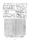
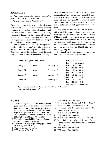
Mr Wills' astronomical observations on his return from Carpentaria to Cooper's Creek by Mr Ellery, Government Astronomer
14
These observations consist of a series of sextant measures for latitude, chronometer error and lunar distances with two observations of Jupiter's satellites. The latitudes, I think, were all approximately computed by himself for the positions of the camps as laid down on his chart correspond very closely in that respect with those that have been since computed carefully from his observations.
But as regards the longitude his chart positions I believe to be “by account” or dead reckoning. As the question of the longitude at which the Expedition reached the Northern part of the continent is a matter of considerable interest and importance, the few observations available for the determination have been very rigorously computed, more especially as although they appear to have been made with every care possible, their results differ considerably from the plotted track at the northern portion of the journey and appear somewhat anomalous.
| Camp CXIX |
(Northernmost camp) |
|
| Camp II |
return |
February |
| Camp III |
return |
February 17 |
| Camp IV |
return |
February 18 |
| Camp XII |
|
February 26 |
No observations made on the journey from Cooper's Creek to Carpentaria have come to hand
It is especially fortunate that on the dates on which Mr Wills made his lunar observations the moon's places were obtained both at Greenwich and Williamstown observatories (having received observations made at Greenwich by last mail) enabling me to correct the observations for errors of the Nautical Almanac which at two of the camps would have made his longitude from 20 to 30 miles east of where they really were.
Subjoined are the positions of the camps at which longitude observations were made:
| Lat |
17° |
53′ |
38″ |
S. |
| Lon (no observations) |
|
|
|
| Lat |
18 |
11 |
38 |
S. |
| Lon |
140 |
59 |
30 |
E. |
| Lat |
18 |
16 |
30 |
S. |
| Lon |
141 |
28 |
00 |
E. |
| Lat |
18 |
23 |
16 |
S. |
| Lon |
141 |
15 |
12 |
E. |
| Lat |
19 |
13 |
47 |
S. |
| Lon |
140 |
55 |
15 |
E. |
Government Astronomer &c
. Victorian Exploring Expedition papers. La Trobe Australian Manuscripts Collection, State Library of Victoria.) [manuscript]")