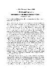
State Library Victoria > La Trobe Journal

No 85 May 2010

83

Ian J. McNiven and Damein Bell
Fishers and Farmers: historicising the Gunditjmara freshwater fishery, western Victoria

'This is a work of undoubted antiquity, but to what remote period of time it owes its origin no one will ever know.'
ADELAIDE TOWN CLERK Thomas Worsnop penned these words in reference to an elaborate stone-walled fish trapping facility used by Aboriginal people from the nearby Lake Condah Mission in southwest Victoria during the late nineteenth century. They appeared in his 1897 compilation text The Prehistoric Arts, Manufactures, Works, Weapons, etc., of the Aborigines of Australia.1 Worsnop's musing acknowledged that the fishtrap had considerable age and a history, albeit one that was inaccessible. Yet conceiving of an ancient Aboriginal past and history on a timescale that we now know is at least 40 – 50,000 years was not what late nineteenth century Europeans had in mind when discussing the antiquity of Aboriginal occupation. Prevailing European views on ancient Aboriginal history were dominated by notions of chronological shallowness and cultural stasis. For example, John Gregory, Professor of Geology at the University of Melbourne, proclaimed authoritatively in 1904 that the earliest archaeological evidence for Aboriginal people 'need not be more than a few centuries old'.2 In many respects such views were limited technologically by an inability to date absolutely the age of cultural remains such as stone artefacts buried in layers of sediment. More influential were philosophies which represented Aboriginal Australians as 'living fossils' for whom history and cultural change seemed not applicable. Historian Bain Attwood recounts a 1917 school primer which states that Aboriginal people 'have nothing that can be called a history ... Change and progress are the stuff of which history is made: these blacks knew no change and made no progress, as far as we can tell'.3 In 1962, at the beginning of the first volume of his magnum opus A History of Australia, Manning Clark remarked that of the 'way of life' of Aboriginal people 'before the coming of European civilisation, little need, or indeed can, be said'.4
Determining how to write a pre-European history of Australia without access to written records has been one of the intellectual and social challenges of the modern Australian nation. As with our nineteenth century forebears, the modern quest is both technological and philosophical. A pre-European human history of Australia is a history of Indigenous endeavour. Acceptance of this fact challenges settler Australians to embrace a plural national history, heritage and identity that transcends the colonial divide. As historian Stuart Macintyre writes in A Concise History of Australia, this new
84
expanded view of history 'is controversial not simply because of cultural ownership but because of the intellectual and emotional challenges it poses. Even if it is permissible to appropriate other cultures, is it possible to comprehend them?'.5 During the second half of the twentieth century, archaeologist and historian John Mulvaney led the charge in championing the importance of creating an ancient Aboriginal history for Australia. Central to Mulvaney's charting of an intellectual path for acceptance of a history of pre-European Australia was unshackling Aboriginal history from the philosophical chains of social evolutionism forged by nineteenth century anthropologists and archaeologists.6 Mulvaney's attack was straightforward and effective – nineteenth century notions of chronological shallowness, cultural stasis and primitivism not only were founded upon racist ideologies underpinning colonialism, they failed to stand up to modern scientific scrutiny and empirical verification. Mulvaney advocated that the writing of an ancient Aboriginal history of Australia required three lines of inter-related evidence – early recordings of traditional Aboriginal societies, archaeological excavation of buried artefacts and features, and reconstruction of ancient environments and the landscape context for these ancient societies. For both archaeological and environmental research the 'time machine' that placed people, artefacts, events and landscapes into a chronological framework was radiocarbon dating.7
Despite the technological and philosophical advances documented by Mulvaney, the extent to which archaeological and environmental reconstructions of Australia's ancient past can be considered history akin to history based upon written records of the past 200 years remains moot. Certainly the binary terms 'history' (European era) and 'prehistory' (pre-European era) reinforce and endorse the colonial and epistemological divide, energising recent calls for abandonment of the term 'prehistory' in the Australian context.8 More fundamentally, can archaeological excavations that document 20,000 years of changing stone tool use or 5000 years of changing use of different shellfish species in Aboriginal diets be considered history? In 1971, Mulvaney remarked that 'man is more than his tools and what he eats'. More critically, he stated that: 'historical comprehension requires that Australia before Cook be envisaged as a period during which the Aborigines both played a creative role and were agents of environmental change. The Europeans did not enter a timeless and changeless land, and Aboriginal Australia deserves more attention than historians have paid it'.9 In this regard, Rhys Jones' concept of 'firestick farming' and deliberate manipulation of vegetation by Aboriginal burning practices was profoundly influential.10 A few years later in Triumph of the Nomads: a history of ancient Australia, historian Geoffrey Blainey produced an ancient history of Aboriginal Australia with a grand narrative of human achievement emphasising individual enterprise and ingenuity.11 The central issue here is agency and the role of archaeological research in bringing to light the humanity of the past and the choices and decisions made by Aboriginal people in constructing their lives
85
and the world within which they operate. It is humanity expressed as agency that meets Macintyre's challenge of making this ancient history comprehensible as history to a broader audience. Yet the fleeting mention of archaeological histories at the start of Macintyre's authoritative history of Australia suggests we still have a long way to go.12
In the 1960s and 70s, Australian archaeology increasingly came under the influence of American paradigms emphasising the role of the environment in shaping hunter-gatherer cultural change. In this intellectual climate, issues of agency and socially-driven cultural change took a back seat. To redress this imbalance, anthropologist Nicholas Thomas delivered a broadside to Australian archaeology, pointing out the theoretical inadequacies of environmentally-driven explanations of the Aboriginal past.13 However, it was archaeologist Harry Lourandos who most conscientiously argued the case for archaeologists to develop more socially-focused explanations of cultural change.14 The focus of Lourandos' archaeological fieldwork was the long-term history of Aboriginal societies in southwest Victoria and in particular the extent to which development of elaborate eel trapping systems and the associated manipulation of waterways reflected deliberate responses by Aboriginal people to changing social and environmental circumstances. The work of Lourandos forms part of a broad range of research which has and continues to be undertaken into the longterm history of Aboriginal fisheries in southwest Victoria. Most of this research has been undertaken with the Gunditjmara people who not only continue their ancestral tradition of eeling, but also have a keen interest in furthering the understanding of the fishery's history. This research has shed fundamental new light on the nature and form of this fishery, including the revelation that the ancestors of the Gunditjmara were much more than hunter-gatherers, they were hydrological engineers who dramatically modified wetland landscapes to assist capture and farming of eels.
In this article we outline past and present information relevant to historicising the Gunditjmara eel fishery. At the outset, we note that a definitive history of this fishery is yet to be written. However, a broad range of documentary evidence is available that not only introduces us to the potential scale and complexity of the fishery in the past, it also helps us identify key questions and associated methodologies critical to conceptualising and constructing a history of the fishery. While some of this information appears in specialist archaeological publications, for the first time we present contemporary information on Gunditjmara eel fishing along with better known nineteenth century historical observations of Aboriginal freshwater fishing in western Victoria and recent results of archaeological and palaeoenvironmental research into the form and antiquity of this fishery. We argue that despite the differing types of historical evidence (oral, textual, archaeological, and palaeoenvironmental) being drawn upon, complementarity and synergy can be achieved through the common theme of human agency. In this sense, our article follows Mulvaney's humanistic approach and charters
86
a multidisciplinary research agenda to establish a socially-informed framework to historicise the Gunditjmara fishery. Furthermore, our agenda represents the fruits of a research partnership between the Gunditjmara and Monash University.15 A basic tenet of this partnership approach is that the starting point for understanding the history of the fishery is the present.

Gunditjmara fishers

The ancestral homeland of the Gunditjmara people is the Western District of Victoria, taking in the southwest corner of the State. The Gunditjmara were there when the Hentys arrived and imposed their whaling station in the 1830s and the Gunditjmara continue to have a strong social, cultural, and land management presence in the region. As with all Aboriginal Australians, land management and cultural heritage are intertwined and inseparable. A key dimension of land management is conservation of ancestral waterways and wetlands. Freshwater not only nourishes Gunditjmara country, it is the ancestral source of eels which play an important role in Gunditjmara subsistence and identity. The interweaving of Gunditjmara land and waterway management, cultural heritage, eeling and identity is exemplified by the Budj Bim National Heritage Landscape and the Tyrendarra Indigenous Protected Area (Fig. 1). Another Gunditjmara community initiative, the Lake Condah Sustainable Development Project, aims to develop sustainable use and management of cultural and environmental values of the region in the context of World Heritage listing. One aspect of the Project is construction of a concrete weir across a European drainage channel to help restore pre-European water regimes and aquatic habitats to Lake Condah and to reactivate the extensive eel aquaculture system (see Special Box Section).16
Gunditjmara are eel fishers and eel farmers – a tradition passed down from their Elders and enshrined across their wetland landscapes in the form of ancient and elaborate stone-walled fish trapping and aquaculture facilities. This fishery is part of oral history with many families having many stories of fishing from the region's waterways. The fishery fed families and provided an income. Grandfathers always had a bag of eels to sell at pubs in the district. As in the past, today's fishery includes other fish such as Toupon, Blackfish and Mountain Trout.17 Fish are caught in wire mesh traps, either box traps or funnel-shaped traps, and fyke nets similar in form to traditional woven basket traps (Figs. 2 to 4). As in the past, fishing involves detailed knowledge of the seasonal cycle of water flows and fish activities and movements.

Historical recordings

Nineteenth century historical records provide tantalising snippets of information on Aboriginal fishing practices of the Western District. For many areas with waterways emptying into the sea, eels were the focus of fishing and a staple protein source. For closed river systems without access to the sea and migrating eels, such as the
87
Corangamite basin, tiny galaxiids were the target fish.19 In addition, James Dawson pointed out that 'there are many varieties of fish in the lakes and rivers, which are eaten by the natives'.20
The two key historical sources on the Gunditjmara fishery are Robinson and Dawson.21 George Augustus Robinson was Chief Protector of Aborigines, Port Phillip Aboriginal Protectorate, between 1839 and 1849. During autumn and winter (March to August) 1841, Robinson travelled around the Western District of Victoria and gained unique insights into Aboriginal culture through first-hand observations and interviews with Aboriginal people and European settlers.22 Robinson's journal recordings are augmented and supported by the subsequent recordings of James Dawson who lived on Kangatong station north of Port Fairy during the 1840s-1860s. Based on close friendships with local Aboriginal people, he became fluent in the Gunditjmara language and his considerable knowledge of Gunditjmara culture was published in 1881 in his Australian Aborigines. Together, Robinson and Dawson detail differing scales of fishing practices employed by the Gunditjmara and neighbouring groups. These practices ranged from small groups spearing fish in lagoons to large-scale engineered facilities with hundreds of metres of constructed embankments, stone walls, and excavated channels. Fundamentally, these records provide archaeologists with glimpses of the potential scale and complexity of the fishery (at least at the time of European contact) and alert researchers to the possible range of archaeological sites that may exist across the landscape today. Equally important, these records invite researchers to investigate the history and complexity of different forms of social organisation required to coordinate operation of large-scale facilities which in some cases involved hundreds and possibly thousands of people. Noel Butlin's estimate of 30 – 35,000 as the immediate pre-contact Aboriginal population of the Western District indicates the potential number of people involved in the fishery.23 On a more basic level, historical references indicate that the Gunditjmara fishery was as much about water management and control as it was about capture of fish.
Small-scale fishing involved individuals and small groups (often families) employing baited lines (without hooks), spears, baskets and weirs. For example, people would proceed to shallow lakes, ponds or marshes to capture eels using special paired eel spears (Fig. 5). During summer eels were dug out of soft mud from the dried beds of swamps.24
Near Terang in April 1841, Robinson noted: 'Saw a dredge for catching small fish. The manufacture same as that employed in making baskets but the shape like a canoe. It was 5 feet long and 18 inches deep the bottom was sharp and worked from a stick and called by the Tjarcote natives, 1. neer.ry.ger, 2. mole' (Fig. 6).25 Dawson also recorded that 'Fishing baskets, about eight or ten feet long, made of rushes in the form of a dragnet, are drawn through the water by two persons'.26 In the 1840s, at a village located south of Caramut, Aboriginal people 'had a superior kind of fishing nets, made like a
88
large round bag with a hoop on the top and a pole attached to it'.27
Dawson describes 'night fishing in deep waterholes' involving the construction of a small 'stage ... formed of limbs of trees, grass, and earth, projecting three or four feet from the bank, and close to the surface of the water'. Using an ignited torch to attract fish, the 'fisher, lying on his face, spies the fish through a hole in the middle of the stage, and either spears or catches them with his hand'.28 These fishing stages appear to be the same as the six 'places the natives made for fishing ... supported by folk sticks' observed by Robinson around the edge of a lagoon along the 'Port Fairy river' (Moyne River) in 1841 (Fig. 7).29
Lourandos points out that spears and nets were used to catch eels during the drier months (especially summer). In contrast, during the wetter months when waterways swell triggering eels to migrate downstream, weir trapping devices were employed.30 Dawson noted that eels were 'prized by the aborigines' and were 'captured in great numbers by building stone barriers across rapid streams, and diverting the current through an opening into a funnel-mouthed basket pipe, three or four feet long, two inches in diameter, and closed at the lower end'.31 It is likely that hundreds of small stone fish traps were used by family groups across the Western District immediately prior to European invasion. In other situations, stone weirs were built at numerous points along waterways. According to Dawson, the celebrated example of such a weir complex was Salt Creek which runs out of Lake Bolac. During autumn rains when many eels exit the lake and swim towards the sea, numerous 'tribes' converge on the creek and at specially allotted locations, individual families set up traps. 'For a month or two the banks of the Salt Creek presented the appearance of a village all the way from Tuureen Tuureen, the outlet of the lake, to its junction with the Hopkins' (a distance of over 40 kilometres).32 Robinson reported that at 'Lake Boloke [Bolac], during the eeling season, from eight hundred to one thousand natives at one time have been seen'.33 With so many people, the total haul of eels must have numbered in the tens of thousands and weighed many tonnes.
Eel fishing at Salt Creek reveals how small-scale, family-sized fishing facilities such as individual weirs across narrow waterways could be brought together into large-scale trapping complexes to take advantage of major runs of fish and to feed numerous groups. Clearly, with so many groups operating weirs, controlling water flows, and removing eels, considerable coordination and negotiations would be required to ensure that participants downstream had access to eels. In this connection, Lake Bolac and Salt Creek were owned by a single group (the 'Boloke tribe') who had regionally recognised 'exclusive rights to the fish' and no doubt to control and manage groups who visited to use the resource.34
Robinson and Dawson also recorded another form of large-scale trapping complex that operated as huge integrated trapping systems. These integrated trapping
89

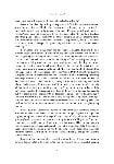
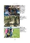
Figure 1 Eileen Alberts and Damein Bell at an eel trap, Tyrendarra Indigenous Protected Area, 2008 (Courtesy: Richard Cornish)
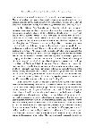
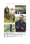
Figure 2 Danny Lovett drying fyke fishing nets, Fitzroy River, October 2007
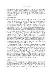
Figure 3 Danny Lovett and Adam Walker retrieving fyke nets, Darlots Creek, October 2007
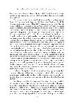
Figure 4 Lucas Bannan and a Blackfish, Darlots Creek, October 2007

(Figures 2, 3 and 4 courtesy Jed MacDonald)
92

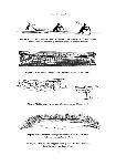
Figure 5 'Bunurong' men spearing eels in a lagoon (Robinson journal, 29 January 1841). A similar technique was used by Aboriginal people of southwest Victoria.

Figure 6 Basket used to dredge for fish (Robinson journal, 21 April 1841).

Figure 7 Fishing stage, Moyne River (Robinson journal, 29 April 1841).

Figure 8 Stake and branch fishing weir, tributary of the Hopkins River (Robinson journal, 24 April 1841).

All images on this and following page courtesy of the Mitchell Collection, State Library of New South Wales.
93

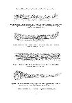
Figure 9 Section of a large stake, branch and basket fishing weir, Moyne River, during use. Note eels being removed from baskets (arrabine) and strung on a nearby holding stick (lengeer) (Robinson journal, 30 April 1841).

Figure 10 Detail of front of a large stake, branch and basket fishing weir, Moyne River (Robinson journal, 30 April 1841).

Figure 11 Detail of back of a large stake, branch and basket fishing weir, Moyne River (Robinson journal, 30 April 1841).

Figure 12 Eel basket (arrabine), a series of which were used in association with a stake and branch fishing weir, Moyne River (Robinson journal, 30 April 1841).

See endnote 71 for technical note on use of images from Robinson's Journal.
94
systems operated at landscape scales and required significant investments of labour to build, maintain and operate. Such investments necessitated negotiated cooperation between numerous people and in many cases numerous clans and possibly tribal groups. Two major types of large-scale fishing facilities were documented by Robinson and Dawson – first, stake and branch or stone weirs over 100m in length and spanning waterways, and second, systems of excavated channels sometimes thousands of metres in length and covering many hectares. For example, on 24 April 1841, near present day Hexham, Robinson noted:
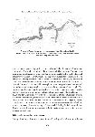
Crossed a creek connecting with the Hopkins. Here I observed a large were [weir] at least 100 yards in length and though the first I had seen, I was assured by its structure and its situation before I reached it that it was the work of the Aboriginal natives. I called to Pevay, my V[an] D[ieman's] L[and] attendant, who had passed it with one of the Tcharcote natives and pointed it out to him. He evinced surprise of it and the natives said it was made by black fellows for catching eels when the big water came and was by them called yere.roc. He said they got plenty eels and then showed us how they did it by biting their heads and throwing them on shore. This were [weir] was made of stout sticks, from 2 – 3 inches thick drove in to the ground and vertically fixed, and other sticks interlaced in an horizontal manner. A hole is left in the centre and a long eel pot made of basket or matting is placed before it and into which the eels gather and are thus taken. It is probable that 2 or 3 such pots are set in large weres [weirs]. This were [weir] must have been 100 yards long, at least, and made with wings or corner pieces at the ends thus, or similar to it (Fig. 8).35
A few days later on the 30 April 1841, Robinson recorded another large stake and branch weir in the district of the 'Port Fairy river' (Moyne River) that 'was the property of a family':
From conversations I had with the natives it appears that this was a favourite spot. It was the home of several families. [blank] took me to several spots where he had resided and had worns or huts. He also took me to a very fine and large weir and went through, with several other of the natives, the process of taking eels and the particular spot where he himself stood and took them. I measured this weir with a tape, 200 feet; 5 feet high. It was turned back at each end and 2 or 3 holes in the middle was left for placing the eel pots as also one at each end. The eel pots are placed over the holes and the fisher stands behind the yere.roc or weir and lays hold of the small end of the arrabine or eel pot. And when the eel makes its appearance he bites it on the head and puts it on the lingeer or small stick with a knob at the end, ... or, if near the bank, he throws them out. The fishing is carried on in the rainy season. Arrabine or eel pot made of bark or plaited rushes with a willow round mouth and having a small end to prevent the eel from rapidly getting away (Figs. 9 to 12).36
More generally, Robinson noted that:
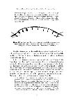
These yere.roc or were [wiers] are built with some attention to the principles of mechanics. Those erected on a rocky bottom have the sticks inserted in a grove37
95
made by removing the small stones so as to form a grove. The were [wiers] is kept in a straightline. The small stones are laid against the bottom of the stick. The upright sticks are supported by transverse sticks, resting on forked sticks as shown above (Fig. 11). These sticks are 3, 4 or 5 inches in diameter. Some of the smaller were [wiers] are in the form of a segment of a circle. The convex side against the current (Fig. 13).38

Figure 13 Plan view of small fishing weir with a series of angled stake braces to help support the structure against the water current (Robinson journal, 30 April 1841). Courtesy of the Mitchell Collection, State Library of New South Wales

Elsewhere, Robinson reported that eel baskets were 'from 9 to 12 feet [2.7 – 3.7m] in length'.39 A rare example of an eel basket was obtained by Alfred Kenyon from Lake Condah in 1910 (Fig. 14). Woven eel baskets continue to be made by Gunditjmara women today (see Fig. 1).
In July 1841, Robinson visited the region immediately east of Gariwerd (The Grampians). It was here that he made two extraordinary recordings of eel trapping facilities that differed in form and scale to what he had seen previously. The first hint of these landscape-scale earthworks was observed on 8 July 1841: 'Passed several dieks [dikes] dug by the natives for draining small lagoons into the large ones for the purpose of catching eels, &c. These channels were from a foot to 18 inches deep and from 8 to 300 yards in length'.40 The following day, Robinson approached low-lying country near Mt William and recorded what remains the largest earthen construction of pre-contact Aboriginal people recorded by Europeans for any part of Australia:
At the confluence of this creek with the marsh observed an immense piece of ground trenched and banked, resembling the work of civilised man but which on inspection I found to be the work of the Aboriginal natives, purposely constructed for catching eels. A specimen of art of the same extent I had not before seen and therefore required some time to inspect it, and which the absence of transport enabled me to do. These trenches are hundreds of yards in length. I measured at one place in one continuous trepple [triple] line for the distance of 500 yards. These treble watercourses led to other ramified and extensive trenches of a most
96

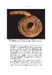
Figure 14 A 1.5m-long eel trap basket from Lake Condah, collected by A. S. Kenyon 1910. SAM #A6431 Courtesy: Aboriginal Ethnographic Collection, South Australia Museum.

tortuous form. An area of at least 15 acres [6 ha] was thus tracd over. The whole reminded me of the extensive circumvaliations of Chatham Lines, in miniature, at which works, at an early period of my life, I [had] been engaged under that veteran engineer Colonel De Arcy for seven years. These works must have been executed at great cost of labour to these rude people the only means of artificial power being the lever, the application and inventive of which force being necessity. This lever is a stick chisel, sharpened at one end, by which force they threw up clods of soil and thus formed the trenches, smoothing the water channel with their hands. The soil displaced went to form the embankment ... To me it was new and particularly interesting and evinced great perseverance and industry on the part of these Aborigines. This description of work is called by the natives cro.cup.per, i.e. Bennewongham [said so].
The plan or design of these ramifications were extremely perplexing and I found it difficult to commit it [to] paper, in the way I could have wished, all its varied form and curious curvilinear windings and angles of every size and shape and parallels, &c. At intervals small apertures left and where they placed their arabine or eel pots. These gaps were supported by pieces of the bark of trees and
97
sticks. In single measurement there must have been some thousands of yards of this trenching and banking. The whole of the water from the mountain rivulet is made to pass through this trenching ere it reaches the marsh; it is hardly possible for a single fish to escape. I observed at short distance higher up, minor trenching was done through which part of the water ran in its course to the more extensive works. Some of these banks were 2 feet in height, the most of them a foot and the hollow a foot deep by 10 or 11 inches wide. The main branches were wider.41
Robinson's journal contains two near identical sketches of the Mt William channels, revealing a repeated attempt to better represent the form of the site (Fig. 15). Ten days later, Aboriginal people made their own drawings of the Mt William channels in Robinson's journal. Robinson stated: 'The natives informed me, in reference to the trenches at Mt William for catching eels, they call them vam. ... The natives made a rude drawing of the vams or trenches for catching eels ... These tracings were first made with a stick on the ground. I then got them to make the same tracings on paper with a pencil' (Fig. 16).42
Dawson provides details on a related form of earthworks used to harvest eels: 'When the streams extend over the marshes in time of flood, clay embankments, two to three feet high, and sometimes three to four hundred yards in length, are built across them, and the current is confined to narrow openings in which the pipe baskets are placed. The eels, proceeding down the stream in the beginning of the winter floods, go headforemost into the pipes, and do not attempt to turn back'.43

Archaeological mapping

To move understanding of Gunditjmara fishing facilities beyond the recordings of Robinson and Dawson requires fieldwork and the fruits of archaeological and environmental research. Without this research, our earliest historical understandings of the Gunditjmara fishery will be forever time-locked to fragmentary European records of the nineteenth century. The recordings of Robinson and Dawson indicate that a fishtrap may represent a single facility owned and used by a family or one small component of a much larger integrated fishing system covering many hectares and operated by numerous clans. As such, it is clear that detailed recording of stone-walled fishing facilities must be combined with a landscape approach to comprehend the potential scale and operation of integrated fishing systems. Detailed archaeological site surveys by the Victorian Archaeological Survey (VAS) and Aboriginal Affairs Victoria (AAV) between 1977 and 1990 recorded five clusters ('systems') of 78 stone-walled fish trapping facilities and associated eel 'holding ponds' at Lake Condah (Figs. 17 and 18).44 Such is the scale of these constructions that archaeologist Peter Coutts and his coresearchers estimated that 'many hundreds of tonnes of basalt boulders have been shifted at Lake Condah to build the intricate network of dams and weirs found there'.45 In the case of the trapping facility mapped in figure 18, the large investment of
98
construction labour reveals creation of a major permanent clan asset intended for re-use over and over again. Although European drainage of Lake Condah rendered the traps inoperable, it was hypothesised by VAS and AAV researchers that many of the trapping facilities operated together depending on different flood water levels. To test this hypothesis, AAV took detailed topographic contour mapping of the lake and using a Geographic Information System (GIS) computer program developed a 'hydrological model' to demonstrate how traps within System 1 in the far southwest corner of the lake linked up at different simulated water levels and flow regimes.46 Similar GIS modelling has been undertaken on trapping facilities along Darlots Creek which connects Lake Condah to the sea.47
One aspect of archaeological mapping that has produced fundamentally new insights beyond that known from historical records is the documentation of what appear to be eel holding ponds associated with eel aquaculture. After heavy winter rains during fieldwork in June 1977, the VAS team noted:
As the lake level dropped, water was trapped in pools, some of which were very deep (3 – 4m) and extensive (50m across). These pools were connected by the now dry or damp stone races and canals or by a series of minor pools. In prehistoric times, fish could have been captured in these ponds and eels could have been taken in traps if they attempted to escape overland along the artificial structures towards the main body of the lake.48
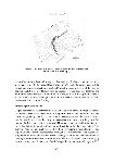
Related inferences concerning holding ponds along Darlots Creek were made by archaeologist Heather Builth.49 Builth found that channels were constructed to divert water from Darlots Creek into adjacent complexes of depressions/swamps augmented by dams and linked through further channels. Based on GIS hydrological modelling, Builth hypothesised further that these 'pens' were used to hold young eels (elvers) swimming upstream during spring and to provide favourable long-term conditions for subsequent growth into adulthood. Following maturation, adult eels would after their normal 7 – 20 year 'terrestrial' life cycle, begin their autumn migration downstream where many were trapped and killed for consumption.50 Based on ponds constructed artificially to 'hold' and 'grow' eels (and most likely other fish), Builth argued that the Gunditjmara practiced 'eel aquaculture'.51
The suggestion that Aboriginal people of western Victoria practiced eel farming was first proposed in 1980 by Harry Lourandos based on archaeological research at Toolondo on the northwest side of Gariwerd.52 Here Aboriginal people excavated a 3km long channel system to connect Budgeongutte Swamp (within the natural range of eels) with Clear Swamp (located to the northwest and outside the natural range of eels). According to Lourandos, 'the size and construction of these drains points to their operation as more than mere eel harvesting devices'.53 The main channel is 2.5m wide and 1m deep but would have been deeper except for erosion infill. It most likely functioned to allow migrating eels to extend their range into a new and previously
99

Figure 15 Pencil sketch plan of an extensive eel channel facility covering 6ha, near Mt William (Robinson journal, 9 July 1841).

Figure 16 Aboriginal pencil drawing of an extensive eel channel facility at Mt William (Robinson journal, 18 July 1841).
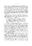
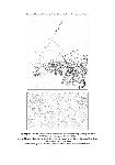
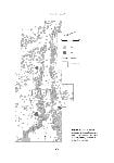
Both courtesy of the Mitchell Collection, State Library of New South Wales
100

Figure 17 Archaeological plan of a small stone-walled fishtrap, Lake Condah (After: Coutts et al. 1978: Fig. 14).

inaccessible swamp. Lourandos argued that engineered channel systems recorded archaeologically at Toolondo, and historically at Mt William by Robinson, increased the habitat and 'annual production of eels', and 'helped to regulate the size of the local eel population at all seasons'.54 This situation led Lourandos to conclude that Toolondo and Mt William 'could be viewed, in effect, as eel 'farms', or at least managed eel habitats'.55 Historian Noel Butlin also thought it appropriate to refer to the Aboriginal eel fishery of the Western District as 'eel farming'.56

Archaeological excavations

Despite considerable insights into the scale and complexity of the Gunditjmara fishery, few inroads have been made into its long-term history and antiquity. Previous researchers generally agree that as most other archaeological sites in the Western District have been radiocarbon dated to the past 3000 – 4000 years, so too it is likely most fish trapping facilities have a similar antiquity.57 However, archaeologists Caroline Bird and David Frankel rightly point out 'there is no direct dating for the stone systems'.58 To overcome this chronological void, we have been developing a methodology to date trapping facilities based on radiocarbon dating of charcoal fragments within sediments burying the lower sections of stone-walled trapping structures. The method is based on the simple proposition that stone walls must be older than the age of sediments burying them and more recent than the age of underlying sediments. Our research began in 2005
101

Figure 18 Archaeological plan of a large stone-walled fishtrap, Lake Condah (After: Coutts et al. 1978: Fig. 9). The scale of this structure indicates it was constructed as a major, long-term clan asset.

and represents a partnership project between Monash University and the Gunditjmara community (through the Winda-Mara Aboriginal Corporation). To date, our excavations have focused on Muldoons Trap Complex located within the flood zone of the southwest margin of Lake Condah. This trap complex, recorded originally in the late nineteenth century, includes 350m of channels constructed variously by addition of basalt block walls and excavation of sediments and removal of basalt blocks from lava bedrock.59 Some excavated basalt blocks weigh more than 50kg and would have required the assistance of strong wooden levers and the lifting powers of two people. Two locations have been targeted for archaeological excavation – sediments partly burying the lower sections of a barrier wall feature and sediments partly filling a channel (Fig. 19, 20 and 22). Excavations reveal that the lower sections of trap features are buried by clay-rich flood sediments, indicating that siltation would have been a maintenance issue for past users of the trap complex. Preliminary radiocarbon dating suggests the trap complex was constructed within the past 500 years. Future excavations aim to build up a more complete picture of the age of stone-walled fishing facilities around Lake Condah and to determine to what extent the intensity of trap construction and use changed through time.

Palaeoenvironmental reconstructions

Coring of sediments from the bottom of Lake Condah provide a history of sediment
102

Figure 19 Excavating channel-fill sediments, Muldoons Trap Complex, Lake Condah, 2008, looking northeast. Back row (L to R): Ian McNiven, Rob Skelly and Joe Crouch (Monash University), front row: Peter Saunders (Winda-Mara Aboriginal Corporation) (Photo: Bruno David).

Figure 20 Finished excavation across channel, Muldoons Trap Complex, Lake Condah, 2008, looking west (Photo: Ian J. McNiven).

Figure 21 Monash University researchers removing a sediment core from the seasonally dry bed of Lake Condah for palaeoenvironmental reconstruction, 2005 (Courtesy: Peter Kershaw).

103
build-up and environmental change linked to changing water levels and vegetation. Initial coring by palaeogeographer Lesley Head suggested that while a date of 9000 years ago for the beginnings of the lake provides a maximum possible date for fishtraps, most fishtraps would have only operated with water levels of the past 2000 years or so.60 More recent coring by Peter Kershaw and his team of palaeoenvironmental researchers from Monash University suggests the lake began around 11,000 years ago with increased water levels commencing 4000 – 5000 years ago (Fig. 21).61 As other lakes and swamps in western Victoria tend to show decreasing water levels at this time, indicative of reduced rainfall, the anomalous situation at Lake Condah may reflect damming of the Darlots Creek outlet of the lake by Aboriginal people.62 It is argued that artificially increasing water levels in Lake Condah extended the period over which the traps could operate. This hypothesis is startling for it reveals a degree of innovative and purposive environmental manipulation and control by Aboriginal people never before documented for pre-European Australia. Indeed, if correct, the Lake Condah dam would equal in age the oldest known dam in the world, documented in Egypt.63 Whatever the case, the new evidence from Lake Condah supports Lourandos' hypothesis that development of the Western District eel enhancement systems may have been 'stimulated' by the onset of drier climatic conditions of 'the last 3000 years or so', which 'would have increasingly endangered aquatic resources'.64 In this respect, current Gunditjmara plans to construct a weir to artificially restore water levels to Lake Condah can be seen as an extension of customary water management practices. Whereas 4000 – 5000 years ago a dam may have been built to offset the drying effects of climate change, currently a weir is being built to offset the drying effects of European drainage.

Future directions

The concept of 'firestick farming' spelt the end of stereotypical representations of Indigenous Australians as hunter-gatherers living passively off the natural productivity of the land.65 More recently, the role of Indigenous Australians in actively manipulating aquatic resources in marine and riverine environments has been explored.66 Understanding the long-term effects of active Indigenous environmental engagement, manipulation, transformation and management is fundamental to informed management of Australia's aquatic biodiversity.67 In this respect, recent research into understanding the long-term history of the Gunditjmara fishery and associated aquaculture has fundamentally challenged notions of Aboriginal people as huntergatherers and natural resource availability. The key to understanding the history of this fishery is multidisciplinary research. It is clear that archaeological excavation of sediments burying traps and related facilities and palaeoenvironmental coring of swamps and potential fish holding ponds will shed fundamentally new insights into the form, complexity and antiquity of this fishery. In both situations, the challenge will be
104

Figure 22 Funnel-shaped entrance to channel at start of Muldoons Trap Complex, Lake Condah, showing location of excavation squares.

105
to obtain a large sample of study sites across a range of wetland landscapes to identify reliable patterns of chronological changes in trap and aquaculture development.
It would be naïve to assume a fishing facility used over hundreds or even thousands of years by numerous generations played the same role in society throughout its long history. This, in essence, is the key to historicising the fishery – to understand how the use of fishing facilities, both individually and collectively, changed through time as a dimension of changing social and environmental conditions. We cannot assume that all fishing facilities seen across the Gunditjmara landscape today were built and used during the same period in history. In this sense, determining when a fishing facility stopped being used and was abandoned is equally as important as ascertaining when it was built. Understanding the degree of contemporaneity of faculties will be a major challenge for future archaeological research.
It is important to always remind ourselves that fishing facilities represent only one aspect of the complex lifeway of the Gunditjmara and their ancestors. To understand and explain long-term patterns in the eel fishery will require equally detailed contextual information on long-term changes in use of other sites in the region such as habitation structures (e.g. stone houses), campsites (e.g. stone artefact scatters), oven mounds, and shell middens along the adjacent coast. Research is also required to further test hypotheses relating to the occurrence of eel smoking trees and eel caching/storage structures.68 Where archaeological research is most lacking is in understanding the spiritual dimensions of the Gunditjmara landscape and in particular ritual sites associated with the fishery.69 Equally challenging will be continuing theoretical debates on the extent to which long-term cultural changes in Western District Aboriginal society reflected largely environmental change or an interplay of environmental and social factors.7071 In all cases, the aim is to construct a long-term history of the Gunditjmara fishery that not only documents its technological dimensions, but also elucidates the social dimensions of the fishery and the complex organisational arrangements necessary to operate small and large-scale fishing facilities. To downplay these organisational dimensions is to miss the key point that operation of the Gunditjmara fishery was and remains quintessentially a social act. In this sense, if archaeologists are to write a history of the fishery they need to continually explore not only the broader social conditions and relationships governing the manufacture, use, and maintenance of fishing facilities through time, but also identify the intentional actions of people, both individually and collectively, embedded in every ancient fishing facility across the Gunditjmara landscape.
90

Lake Condah Restoration Project

Restoring Lake Condah.
For the past 25 years, our Gunditjmara community has worked hard to achieve the restoration of Lake Condah.
Lake Condah was drained in 1954 with the construction of the Condah drain.
The restoration of the lake means many things to our community, including the continuation of our eel aquaculture, the revitalization of the environment and its ecologies, and most importantly, as a spiritual and physical healing for our country and ourselves.
During the 1980s, we gained the resources to design and install a trial weir at Lake Condah in 1991 to direct water from the Condah drain to the lake's bed.
The trial weir did not achieve the successful outcomes we had desired.
The trial weir did adjust the water flow to the southern part of the lake; the Condah drain's efficiency continued to take the water away.
The trial weir also suffered from vandalism.
Since 2002, the Lake Condah Sustainable Development Project (LCSDP) has supported the Lake Condah Restoration Project progressing through a series of major activities including:
Lake Condah Water Restoration Business Plan,
Lake Condah Water Restoration Project Hydrological Feasibility Study,
Shortfinned Eel Harvest Capacity of the Budj Bim Landscape,
Mt Eccles Lava Flow Botanical Management Plan,
Lake Condah Biodiversity Assessment Study,
Lake Condah Restoration Project Proposed Weir Geotechnical Investigation,
Lake Condah Restoration Weir Installation Cultural Heritage Management Plan,
Environmental Water Requirements of Darlot Creek and Lake Condah,
Lake Condah Restoration Conservation Management Plan,
Lake Condah Water Restoration Project - Weir Construction Tender Document.18
Through this incredible body of work, the LCSDP has continually consulted with surrounding landowners, the broader community and government agencies regarding issues, concerns, benefits and progress of the restoration project.
The design of the weir features a structure around 90 meters long to allow safe passage for fish species and the environmental flow of water.
The installation commenced in January 2010 and is scheduled for completion by April-May 2010
We have prepared a two year monitoring period to follow the installation of the weir to further develop understanding of the lake.
Continuing Aquaculture at Lake Condah.
Our Gunditjmara community will continue our aquaculture heritage using the stony
91
landscape and wetlands that surround Lake Condah and the broader Budj Bim National Heritage Landscape.
When we say we 'will continue our heritage', we place that statement in context to the interruption that the European invasion, colonization and subsequent Australian governments and society has caused to our aquaculture.
The transmission of cultural knowledge of Lake Condah and our aquaculture has come in many forms.
Gunditjmara people value our oral traditions and stories as much as we do recording our recent activities.
For what cultural knowledge that has been handed down through the stories of our Elders, a lot of knowledge has been lost.
To supplement the loss, we have accessed other sources of knowledge transmission from early ethnographic evidence as well as older non-Aboriginal people who grew up at Lake Condah and along the lava flow and wetlands.
An additional source of knowledge transmission has been the application of Western sciences including archaeology, anthropology and hydrology to Lake Condah and our aquaculture.
It is especially rewarding when the Western sciences confirm aspects of our traditional stories that have been passed down.
It is a testament to our Gunditjmara ancestors and their engineering when today's science and technology confirms the best place to install the new weir is where our ancestors placed their weir thousands of years ago.
Today, the restoration of Lake Condah features all the relationships we have had to develop, resolve and maintain not only with ourselves, but with other Aboriginal groups and the broader non-Aboriginal community, institutions and governments.
These relationships will be required when we commence the continuation of our aquaculture for our mob to harvest a feed of eel and fish and for our commercial trading with the rest of the world.
A major challenge for our commercial aquaculture will be for seafood industry regulators to include our recognized customary rights within the commercial industry; and also recognize a traditionally engineered aquaculture system that is a composition of a cultural and natural landscape which is unique in the world.
The intricate relationships that our ancestors had within Gunditjmara clans and with other traditional groups are comparable to the relationships that we have developed today through the restoration project and other activities.
The archaeological conclusions that have been reached over the past centuries are affected by limited understandings of Gunditjmara society through time by past archaeological research.
The refinement of those past conclusions will be adjusted through time and into the future by new archaeological research and work.
The new archaeological research outcomes will be especially valuable as the activities include Gunditjmara people managing and participating in the investigations and contributing to new conclusions.

1

Thomas Worsnop, The Prehistoric Arts, Manufactures, Works, Weapons, etc., of the Aborigines of Australia, Adelaide: Government Printer, 1897, p. 105.

2

John W. Gregory, 'The antiquity of Man in Victoria', Proceedings of the Royal Society of Victoria, 1904, no. 17, p. 141.

3

Cited in Bain Attwood, 'Making history: imagining Aborigines and Australia', in T. Bonyhady and T. Griffiths, eds, Prehistory to Politics: John Mulvaney, the Humanities and the public intellectual, Carlton South, Vic.: University of Melbourne Press, 1996, p. 102.

4

C. M. H. Clark, A History of Australia. Volume 1, From the Earliest Times to the Age of Macquarie, Carlton, Vic.: Melbourne University Press, 1962, p. 4. For broader critical discussion of this topic, see Tom Griffiths, Hunters and Collectors: the antiquarian imagination in Australia, Melbourne: Cambridge University Press, 1996; Tom Griffiths, 'In search of Australian antiquity', in Bonyhady and Griffiths, Prehistory to Politics, pp. 42-62.

5

Stuart Macintyre, A Concise History of Australia, Cambridge: Cambridge University Press, 2nd edition, 2004.

6

John Mulvaney, 'The Australian Aborigines 1606-1929: option and fieldwork', Historical Studies Australia and New Zealand, 1958, vol. 8, no. 30, pp. 131-51, 297-314; John Mulvaney, The Prehistory of Australia, New York: Frederick A. Praeger, 1969; John Mulvaney, 'Developing a perspective on mankind: the study of prehistory', in D. Dufty, G. Harman and K. Swan, eds, Historians at Work: investigating and recreating the past, Sydney: Hicks Smith and Sons, 1973. For an excellent overview of Mulvaney's contribution to Aboriginal historiography, see Attwood, 'Making history, imagining Aborigines and Australia', pp. 98-116. For an extended discussion of how the theoretical framework of social evolutionism was central to racist representations of Aboriginal Australians as primitive and unevolved, see Ian J. McNiven and Lynette Russell, Appropriated Pasts: Indigenous peoples and the colonial culture of Archaeology, Walnut Creek, California: AltaMira Press, 2005.

7

John Mulvaney, 'A new time machine', Twentieth Century, 1952, pp. 16-23; Mulvaney, The Prehistory of Australia.

8

For an extended discussion of the problematic nature of the term 'prehistory', see McNiven and Russell, Appropriated Pasts, pp. 218-222.

9

John Mulvaney, 'Discovering Man's place in nature', Prehistory and Heritage: the writings of John Mulvaney, Occasional Papers in Prehistory, Canberra, Department of Prehistory, Research School of Pacific Studies, The Australian National University, 1990, p. 112.

10

Rhys Jones, 'Fire-stick farming', Australian Natural History, no. 16, 1969, pp. 224-228.

11

Geoffrey Blainey, Triumph of the Nomads: a history of ancient Australia, South Melbourne, Vic.: Macmillan, 1975.

12

Macintyre, A Concise History of Australia, Chapter 1: Beginnings, pp. 1-15.

13

Nicholas Thomas, 'Social theory, ecology and epistemology: theoretical issues in Australian prehistory', Mankind, no. 13, pp. 165-177.

14

For an extended discussion on the development of a socially-oriented approach to Australian archaeology, see Ian J. McNiven, Bruno David and Bryce Barker, 'The social archaeology of Indigenous Australia', in Bruno David, Bryce Barker and Ian J. McNiven, The Social Archaeology of Australian Indigenous Societies, Canberra: Aboriginal Studies Press, 2006, pp. 2-19.

15

For a detailed discussion of the tenets of partnership research between Indigenous communities and archaeologists, see McNiven and Russell, Appropriated Pasts, Chap. 8.

16

http://www.deh.gov.au/cgi-bin/ahdb/search.pl

17

Heather Builth, 'Gunditjmara environmental management: the development of a fisher-gathererhunter society in temperate Australia', in J. Kim, C. Grier and J. Uchiyama, eds, Beyond Affluent Foragers, Oxford: Oxbow Books, 2006; Lake Condah Aboriginal Education Committee and Puunyart, Memories Last Forever, Abbotsford, Vic.: Aboriginal Histories Programme, 1988; Merryl K. Robson, Keeping Culture Alive, Hamilton, Vic.: Hamilton City Council, 1986; Vanda Savill, Dear Friends, Lake Condah Mission, Etc., Hamilton, Vic.: Kalprint Graphics, 1976.

19

Ian J. McNiven, 'Aboriginal settlement of the saline lake and volcanic landscapes of Corangamite Basin, Western Victoria', The Artefact, no. 21, 1998, pp. 63-94; Thomas Learmonth, 1853 letter quoted in T. F. Bride, ed., Letters from Victorian Pioneers, Melbourne: Government Printer, 1898, p. 40.

20

James Dawson, Australian Aborigines: the languages and customs of several tribes of Aborigines in the Western District of Victoria, Australia, Melbourne: George Robertson, 1881, p. 19.

21

The importance of these historical sources has been long-recognised by researchers – e.g. Peter J. F. Coutts, Rudy K. Frank and Phil Hughes, Aboriginal Engineers of the Western District, Victoria, Records of the Victorian Archaeological Survey, no. 7, 1978; Jan Critchett, A 'Distant Field of Murder': Western District frontiers 1834-1848, Carlton, Vic.: Melbourne University Press, 1990; Harry Lourandos, 'Change or stability? Hydraulics, hunter-gatherers and population in temperate Australia', World Archaeology, no. 11, 1980, pp. 245-266; Harry Lourandos, 'Swamp managers of southwestern Victoria', in D. J. Mulvaney and J. P. White, eds, Australians to 1788, Broadway, NSW: Fairfax, Syme & Weldon, 1987, pp. 292-307; Gary Presland, 'The journals of George Augustus Robinson', The La Trobe Library Journal, no. 43, 1989, pp. 9-12; Elizabeth Williams, Complex Hunter-Gatherers: a late Holocene example from Temperate Australia, BAR International Series no. 423, 1988.

22

Robinson's original journals are held in the Mitchell Collection of the State Library of New South Wales, Sydney. Microfilm copies of the journals are held by the State Library of Victoria. Published transcriptions of the journals have been made by: Ian D. Clark, ed., The Journals of George Augustus Robinson, Chief Protector, Port Phillip Aboriginal Protectorate, Volume Two: 1 October 184031 August 1841, Melbourne: Heritage Matters, 1998; Gary Presland, ed., Journals of George Augustus Robinson MarchMay 1841, Records of the Victorian Archaeological Survey 6, Melbourne: Ministry for Conservation, 1977; and Gary Presland, ed., Journals of G. A. Robinson May to August 1841, Records of the Victorian Archaeological Survey, no. 11, Melbourne: Ministry for Conservation, 1980. Quotes from Robinson's journals used in this paper are based primarily on Clark's transcriptions modified in a few places following McNiven's examination of Robinson's original journals.

23

Noel G. Butlin, Economics and the Dreamtime: a hypothetical history, Cambridge: Cambridge University Press, 1993, p. 135.

24

Dawson, Australian Aborigines, pp. 94-95.

25

Clark, The Journals of George Augustus Robinson, p. 141.

26

Dawson, Australian Aborigines, p. 94.

27

Thomas 1858 cited in Williams, Complex Hunter-Gatherers, p. 64.

28

Dawson, Australian Aborigines, p. 95.

29

Clark, The Journals of George Augustus Robinson, p. 161.

30

Lourandos, 'Swamp managers of southwestern Victoria', p. 300.

31

Dawson, Australian Aborigines, p. 94.

32

Ibid, p. 94.

33

Alfred S. Kenyon, 'The Aboriginal Protectorate of Port Phillip: Report of an Expedition to the Aboriginal Tribes of the Western Interior by the Chief Protector, George Augustus Robinson', Victorian Historical Magazine, vol. 12, no. 47, 1928, p. 146.

34

Dawson, Australian Aborigines, pp. 94-95.

35

Clark, The Journals of George Augustus Robinson, p. 145.

36

Ibid, pp. 162-163; Kenyon, 'The Aboriginal Protectorate of Port Phillip', p. 147.

37

Robinson originally wrote 'hollow' but crossed it out and replaced it with 'grove'.

38

Clark, The Journals of George Augustus Robinson, p. 163.

39

Kenyon, 'The Aboriginal Protectorate of Port Phillip', p. 157.

40

Clark, The Journals of George Augustus Robinson, p. 306.

41

Ibid, p. 308.

42

Ibid, p. 321.

43

Dawson, Australian Aborigines, p. 94.

44

Anne Clarke, Lake Condah Project Aboriginal Archaeology Resource Inventory, Occasional Report no. 36, Melbourne: Victoria Archaeological Survey, Department of Conservation and Environment, 1991; Coutts et. al., Aboriginal Engineers of the Western District, Victoria; Nora van Waarden and Bob Wilson, 'Developing a hydrological model of the Lake Condah fish traps in western Victoria using GIS', in I. Johnson, ed., Methods in the Mountains, Sydney: Sydney University Archaeological Methods Series no. 2, Archaeological Computing Laboratory, Department of Prehistoric and Historical Archaeology, The University of Sydney, 1994, pp. 81-90.

45

Peter Coutts, Dan Witter and Deborah Parsons, 'Impact of European settlement on Aboriginal society in western Victoria', Search, no. 8, 1977, p. 197.

46

van Waarden and Wilson, 'Developing a hydrological model of the Lake Condah fish traps'.

47

Heather Builth, 'Mt Eccles lava flow and the Gunditjmara connection: a landform for all seasons', Proceedings of the Royal Society of Victoria, no. 116, 2004, pp. 163-182; Builth, 'Gunditjmara environmental management'.

48

Coutts et. al., Aboriginal Engineers of the Western District, Victoria, p. 28.

49

Heather Builth, The Archaeology and Socioeconomy of the Gunditjmara: A Landscape Analysis from Southwest Victoria, Australia', Unpublished PhD thesis, Adelaide, Flinders University, 2002, pp. 242-244; Builth, 'Mt Eccles lava flow', p. 175.

50

Builth, The Archaeology and Socioeconomy of the Gunditjmara, p. 253.

51

Ibid.

52

Lourandos, 'Change or stability?', pp. 253-254.

53

Ibid, p. 254.

54

Lourandos, 'Swamp managers of southwestern Victoria', p. 306.

55

Ibid, p. 307.

56

Noel G. Butlin, Our Original Aggression: Aboriginal populations of Southeastern Australia 1788-1850, Sydney: George Allen & Unwin, 1983, p. 126.

57

Coutts et. al., Aboriginal Engineers of the Western District, Victoria; Lourandos, 'Change or stability?'; Harry Lourandos, 'Intensification: a late Pleistocene-Holocene archaeological sequence from southwestern Victoria', Archaeology in Oceania, no. 18, 1983, pp. 81-94; Harry Lourandos, Continent of Hunter-Gatherers: new perspectives in Australian prehistory, Cambridge: Cambridge University Press, 1997; Williams, Complex Hunter-Gatherers.

58

Caroline F. M. Bird and David Frankel, 'Chronology and explanation in western Victoria and south-east South Australia', Archaeology in Oceania, vol. 26, 1991, pp. 1-16.

59

Nineteenth century recordings of this site were brought to our attention by Tom Richards. See Steve Hemming, 'An Aboriginal fish trap from Lake Condah, Victoria', Journal of the Anthropological Society of South Australia, no. 23, 1985, pp. 2-6; Worsnop, The Prehistoric Arts, pp. 104-105.

60

Lesley Head, 'Using palaeoecology to date Aboriginal fishtraps at Lake Condah, Victoria', Archaeology in Oceania, no. 24, 1989, pp. 110-115.

61

Heather Builth, A. Peter Kershaw, Chris White, Anna Roach, Lee Hartney, Merna McKenzie, Tara Lewis and Geraldine Jacobsen, 'Environmental and cultural change on the Mt Eccles lava-flow landscapes of southwest Victoria, Australia', The Holocene, no. 18, 2008, pp. 413-424.

62

Ibid.

63

Donald R. Hill, A History of Engineering in Classical and Medieval Times, London: Routledge, 1996, p. 50.

64

Lourandos, 'Change or stability?', p. 255; Lourandos, Continent of Hunter-Gatherers, p. 221.

65

Beth Gott, 'Aboriginal fire management in south-eastern Australia: aims and frequency', Journal of Biogeography, no. 32, 2005, pp. 1203-1208; Jones, 'Fire-stick farming'.

66

Builth, 'Mt Eccles lava flow'; Lourandos, 'Change or stability?'; Paul Humphries, 'Historical Indigenous use of aquatic resources in Australia's Murray-Darling Basin, and its implications for river management', Ecological Management & Restoration, no. 8, 2007, pp. 106-113; Ian J. McNiven, 'Inclusions, exclusions, transitions: Torres Strait Islander constructed landscapes over the past 4000 years, northeast Australia', The Holocene, no. 18, 2008, pp. 449-462.

67

Lesley Head, Second Nature: the history and implications of Australia as Aboriginal landscape, New York: Syracuse University Press, 2000, provides an excellent summary and discussion of the technical and philosophical implications of long-term Aboriginal landscape modification for modern environmental management.

68

Builth, The Archaeology and Socioeconomy of the Gunditjmara; Builth, 'Gunditjmara environmental management'.

69

Ritual dimensions of water management and fishing are rarely explored by archaeologists. For an example of the ritual archaeology of Aboriginal marine environments, see Ian J. McNiven, 'Saltwater People: Spiritscapes, maritime rituals and the archaeology of Australian indigenous seascapes', World Archaeology, no. 35, 2003, pp. 329-49.

70

For research approaches that emphasise environmental change, see Bird and Frankel, 'Chronology and explanation in western Victoria' and Builth et. al., 'Environmental and cultural change'. For research approaches that emphasise an interplay of environmental and social factors, see Lourandos 'Change or stability?', Lourandos, Continent of Hunter-Gatherers; McNiven, 'Aboriginal settlement of the saline lake', and Williams, Complex Hunter-Gatherers.

71

All Robinson journal images used in this paper have been cleaned-up in Photoshop® such that paper colourations and written text surrounding images have been erased and the ink drawings transformed into a grayscale.

18

Phillip Ruge, Lake Condah Water Restoration Business Plan, 2004. Lake Condah Sustainable Development Project; Christopher Gippel, Phil Macumber, Geoff Fisher, Lance Lloyd and Marcus Cooling, Lake Condah Water Restoration Project Hydrological Feasibility Study, 2006. Fluvial Systems Pty Ltd, Stockton. Glenelg-Hopkins Catchment Management Authority, Hamilton; Lachlan J. McKinnon, Shortfinned Eel Harvest Capacity of the Budj Bim Landscape, 2007. Final Report to Winda Mara Aboriginal Corporation. Audentes Investments; G.W. Carr, D. Frood, N. R. Roberts, N. Rosengren, Mt. Eccles Lava Flow Botanical Management Plan: Literature Review, 2006. Victoria: Ecology Australia; David Crook, Jed Macdonald, Chris Belcher, Damien O'Mahony, David Dawson, Danny Lovett, Adam Walker and Lucas Bannam, Lake Condah Restoration Project: Biodiversity Assessment, 2008. Arthur Rylah Institute for Environmental Research Technical Report Series No. 180. Department of Sustainability and Environment, Heidelberg, Victoria; GHD Pty Ltd, Lake Condah Restoration Project Proposed Weir: Geotechnical Investigation, 2008. Report by Coffey Geotechnics Pty Ltd, Mile End, South Australia; Ian J. McNiven, Lake Condah Restoration Weir Installation: Cultural Heritage Management Plan, 2008. Report to Dept. of Sustainability & Environment, Portland, Victoria; Christopher J. Gippel, B. G. Anderson, G. Kerr, Lance Lloyd, and Marcus Cooling, Environmental Water Requirements of Darlot Creek and Lake Condah: Issues Paper, 2008. Fluvial Systems Pty Ltd, Stockton. Glenelg Hopkins Catchment Management Authority, Hamilton; Christopher J. Gippel, B. G. Anderson, Marcus Cooling, Lance Lloyd and G. Kerr, Environmental Water Requirements of Darlot Creek and Lake Condah: Final Recommendations, 2008. Fluvial Systems Pty Ltd, Stockton. Glenelg Hopkins Catchment Management Authority, Hamilton; Chris Johnston, Lake Condah Restoration Conservation Management Plan, 2008. Report to Windamara Aboriginal Corporation. Melbourne: Context; Lake Condah Water Restoration Project: Weir Construction Tender Document, 2009. Victoria: Dept of Sustainability and Environment.