The Map Section of the State Library
THE MAP Section of the State Library of Victoria prides itself on its strong holdings of historical and current maps, both Australian and international. With approximately 110,000 maps, it has one of the major collections of cartographic material in Australia. Of the state/national library collections in Australia, it ranks third, after the National Library of Australia which has about 600,000 sheets, and the State Library of New South Wales (Mitchell and Dixson Libraries) with 132,000 sheets.
As the earliest printed catalogues of the Library record, the State Library has collected maps almost from its foundation in 1856.
The Catalogue of the Melbourne Public Library for 18611 has a section entitled ‘Globes, Charts, Maps and Surveys’, which lists the Celestial and Terrestrial globes known to have stood in Queen's Hall, as well as single charts and maps, some mounted on rollers, and about 26 volumes of maps, making over 1000 in all. The
Supplemental Catalogue2 for 1865 includes a few nautical charts, maps donated by the Geological Survey and the Ordnance Survey of Great Britain, and by the War Office, as well as atlases donated by foreign governments, including those of Russia, Sweden and Italy. The Preface to the catalogue states that ‘the [British] War-office, the Ordnance, and the Admiralty, furnished an extensive supply of military and naval history, surveys, maps, and charts, with which branches of information the Library has been hitherto imperfectly provided’.
3The
Catalogue of Donations to the Public Library of Victoria from 1856 to 18724 includes many more charts donated by the British Admiralty, and war maps of places that had been ‘in the news’, such as the Crimea, and the sieges of Lucknow, Jhansi and Delhi during the Indian Mutiny. Also listed in this section are documents which presumably did not fit into any other category, such as Hansen's ‘Tables de la Lune’ (1857), ‘Gun Practice, Plates Illustrative of, and ‘Historical Legi-graphical Chart of Landed Property in England, from the time of the Saxons to the present era’ (1805).
By 1880, the
Catalogue of the Public Library of Victoria5 had 42 pages of entries for maps and charts, 6 of them of Australasian material, 14 of ‘Great Britain, its colonies and possessions’, most of which were of India. This reflects the practice, instigated largely by Redmond Barry, of requesting material for the Library from overseas government sources, particularly from the British and other colonial governments. The emphasis on Indian maps and other documents may stem partly from the fact that, at the time the collections were being developed, there was considerable interest in that country as a result of the Survey of India and the British army involvement in the 1857–58 Mutiny.
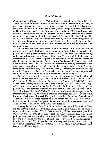
6 Maps resulting from these surveys were very detailed, and often very beautiful, in spite of having a practical or military purpose, as can be seen in the example reproduced here [
Fig. 1].
6
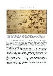
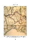
The policies of soliciting donations from overseas governments, and, where this was not possible, of arranging purchases from European booksellers, underpin the rich holdings of map material from the mid-to-late nineteenth century. The Admiralty chart collection, which now numbers about 4500 sheets, dates from the 1820s to the 1990s [see
Fig. 2]. The British Ordnance Survey covers a large part of England and Wales, plus parts of Ireland and Scotland, at scales of one-inch and six-inches to one mile. Much sought-after by genealogists, these maps are remarkably detailed, showing streets, railway lines, industrial sites and public buildings in urban areas, and villages, farms, fences, natural features, and often obscure place-names in the country
[Fig. 3]. The State Library's holdings are the best coverage of this material in any library in the Southern Hemisphere.
At the same time as the holdings of overseas maps have been built up, local Victorian material has been steadily added to the Library's holdings, especially under the provisions of the 1869 State Copyright Act, and its successors, the
7
8
(Commonwealth) Copyright Act of 1968, and the (Victorian) Libraries Act of 1988. The Victorian legislation requires publishers to deposit with the State Library one copy of every book, journal, newspaper, print, poster and
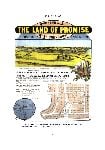
map they publish. This is probably the means by which many of the commercially-printed maps from map-makers such as Ham, Proeschel, Whitehead, Robinson, and Sands and McDougall have been acquired. Legal Deposit remains an important source of maps produced by Victorian commercial map-makers, alongside the so-called Premier's Directive (Circular No. 85/5), which requires deposit of maps produced by state government agencies. In recent years this requirement became much harder to enforce, as departments have been broken up or privatised, and their maps produced only for internal use or on computer screens.
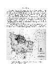
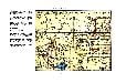
In the past, however, large numbers of maps produced by state government agencies were deposited with the Library, some in the form of sheet maps such as the parish and township plans from the Surveyor General's or Lands Department, mining and geological maps from the Geological Survey of Victoria, and the Melbourne and Metropolitan Board of Works’ large series of drainage plans. The Lands Department also donated about 100 volumes of their cadastral (land ownership) plans, along with a hand-written index. The same ‘scrap-book’ format was used by companies of real estate agents, several of whose collections of advertising material are held. These are mainly plans of subdivision, some of them lavishly illustrated, the best-known being the Vale, Haughton and Batten & Percy collections. An example of such maps (which are discussed in detail by Miles Lewis in his article) is given at
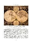
Fig. 9.Retrospective acquisition has been by purchase, deposit and donation, although there have not been any large bequests of map material such as the Petherick Collection of the National Library of Australia or the Dixson and Mitchell Collections of the State Library of New South Wales. However, in the early 1980s a large collection of atlases was donated by the Victorian Parliamentary Library, adding particularly to the holdings of Indian and European material. The importance of the State Libraries of New South Wales, Victoria and South Australia as repositories for material relating to early Australian exploration was recognized in 1885 by the British Museum, which donated to each library a folio entitled ‘Facsimiles of old charts of Australia’. Our set of these decorative maps, which have been taken by some to indicate sixteenth-century Portuguese discovery of the northern and eastern coasts of Australia, has been hand-coloured and mounted
[Fig. 4].Among the treasures of the State Library are maps of very different kinds. There are, for instance, world maps by Blaeu, Goos, Hondius and Visscher, one of which is reproduced in this number of
The La Trobe Journal [
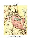
Fig. 5]. Two treasures of great local interest are the large map of Victoria published by Arrowsmith in 1853 [
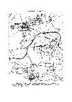
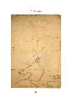
Fig. 8]; and, perhaps most fascinating of all to Victorians, John Helder Wedge's manuscript map showing Port Phillip and the tract of land supposedly ceded by the Aborigines to John Batman in 1835 [
Fig. 6]. Another map of strong local interest is the pirated copy of Frederick Proeschel's
Pocket Map of the Roads to all the Mines in Victoria (1853), which is reproduced here at
Fig. 7. 9
As is to be expected, the nineteenth- and twentieth-century Victorian material is heavily used for a range of research purposes, such as family and local history, heritage studies, land development investigations and architectural research. Holdings for other states and for overseas countries are naturally not as strong as those for Victoria, but nevertheless continue to be built up in line with the Library's Collection Development Policy.
The size of the Map Collection has never been easy to determine precisely, but was estimated to be about 50,000 sheets in 1973, 73,000 in 1976, and now (in 2001) about 110,000. In addition to flat sheet maps, the reference book collection numbers about 5000 volumes — atlases, gazetteers, map catalogues, histories of cartography, and books and serials on map-keeping. Some other map libraries have lost status within their institutions, been absorbed or dispersed, or had their contents superseded as a result of an institutional preference for electronic format rather than paper sheet format. The State Library of Victoria, though, maintains the importance of the Map Collection, particularly because of its strong holdings of historical material. However, to remain relevant, it must continue to acquire current printed maps, together with other formats such as CD-ROMs and electronic data. The latter have not been strongly acquired because of the difficulty of keeping up-to-date with the output of constantly changing information.
10
Conventional paper maps are stored in the Map Room in horizontal cases, vertical files, filing cabinets for small-sized items, and custom-made boxes on shelves for rolled maps and folio collections. Most flat sheets are placed into specially-designed polyethylene or polypropylene bags to save wear-and-tear on fragile paper. They are classified by a scheme designed for map collections, known as ‘Boggs and Lewis’, which is based on a geographic breakdown, with subject code and date as secondary and tertiary elements of the call number. The book collection is of course classified by Dewey, and is catalogued by the Information Resources Department, not Maps staff.
The Map Collection, initially housed, according to the early catalogues, on the mezzanine floor of Queen's Hall, has had a peripatetic existence. It was kept very unsatisfactorily in various parts of the Dome basement, with cabinets jammed between bookshelves, making them almost impossible to access. Later it was held in
11
the La Trobe Wing (now Vicnet), and from about 1975 to 1993, in a section of the Dome annulus and the Dome Reading Room itself. It was moved to its present location in the McCallum Building in 1993, and will eventually be housed, along with other parts of the Rare Printed Collections, in the McArthur Gallery, at present part of the temporary National Gallery. It is to be hoped that access to its valuable resources will continue to be relatively easy for users, as an ‘open-door’ policy has always been an aim of the Map Section. At present inquirers are able simply to walk in and ask to consult maps for almost any purpose — travel, family and local history, architectural research, or even more esoteric uses such
as feng shui and astrology! In spite of major moves to make data of all sorts, including maps, available digitally, online and via the Internet, users continue to need them in paper format
The Library's card catalogue — and before it the fixed-location index — included maps in book format, atlases, and some sheet maps, often described in a brief or idiosyncratic way. Maps were catalogued manually on to an internal card catalogue and index from 1970, and it was not until 1997 that sheet maps began to be included in the DYNIX automated catalogue. Unfortunately, the project to carry out this task was short-lived, and only cataloguing of Victorian single-sheet maps has come near to completion. A small part of the auction plan collection is being catalogued directly on to the new ‘Voyager’ system, and some of the images themselves have been digitised so that they can be viewed with the catalogue record. It is hoped to extend this project to many more maps, in the same way that images in the Picture Collection have been recorded.
In these days of multi-skilling, very few staff working in map collections have had specific training in the area, or even a background in geography or environmental studies. They may have worked in other areas of large or small libraries, and have subject expertise in almost any field, although an interest in world affairs, travel, history and the natural environment certainly helps!
The first Map Librarian, appointed in 1970, was Patricia Alonso, to whom the collection really owes its firm foundation and its early development. Patricia had come from the American Geographical Society in New York, and then the Map Library at the University of Melbourne. She was a geographer
and a librarian, and brought to the job both organisational skills and an ability to make contacts with mapping agencies world-wide. She begged donations of maps from overseas and interstate, and instigated depository arrangements with the Victorian Lands Department and the Federal agencies producing topographic and geological maps (now AUSLIG and AGSO) — important bases for any map collection. She purchased maps where donations could not be solicited, and also arranged for the housing, classification and indexing of maps into the collection. She was a foundation member of the Australian Map Circle, an organisation devoted to the promotion, use and enjoyment of maps both in and outside libraries. She served as editor of the Circle's journal,
The Globe, and helped to arrange some of its early conferences. Her strong interest in environmental and planning issues led her away from map librarianship into research and teaching at RMIT and the University of Melbourne, where she
12
13
14
15
completed her PhD on ‘Environmentalism and Land-use Planning’ in 1985. She continued to write articles for journals in these fields, as she had done on maps and libraries during her earlier career. Sadly, Patricia died of a brain tumour in 1989, at the age of only 44.
Even more untimely was the death, in September 2000, of Estelle Canning, Assistant Map Librarian for 15 years. For those of us who worked with her and valued her so highly, the occasion of this article provides an opportunity for us to pay tribute to her and to acknowledge her contribution to the work of the State Library.
The Map Section, I should like to think, has benefited from the remarkable continuity of its small staff. The present Map Librarian has held her position since 1974, and the Rare Printed Collections technician, who works half-time in Maps, has held his since 1987. The fascination of ‘map-keeping’ shows no sign of slackening.
Judith Scurfield
The State Library of Victoria Foundation gratefully acknowledges the contribution of the Map Circle of Australia towards the cost of reproducing items from the Map Collection in this number of The La Trobe Journal.
16

. Map Collection, State Library of Victoria [map]")


, surveyor to the Port Phillip Association, to show Batman's explorations and the land supposedly ceded by the Aborigines. It came to the Library's collection from Robert Russell, via Mrs Eliza Newton, widow of Batman's clerk and executor E.T. Newton. Interestingly, it shows land reserved for a township (Melbourne) on the southern side of the Yarra River, called the Batman by Wedge. Map Collection, State Library of Victoria. [map]")