Maps for Building Research
ARCHITECTURAL HISTORIANS often underrate the potential value of maps in their work, because they tend to think only in terms of architectural drawings
1 and written documents, which are the bread and butter of the discipline. This is not entirely their fault, because maps are heterogeneous in character, generated in a number of ways and held in a variety of places. Only with experience does one learn what is likely to be useful. Maps can be used to determine not only the existence or otherwise of a building and its precise location, which is what one might expect, but its size and footprint (or shape in plan), and in some cases the number of storeys, the materials, the construction and even the visual appearance.
In research of this sort, there are two fundamental principles which are often forgotten. The first — when sources are known — is to consider why they were compiled and by whom, because this tells us what information may reasonably be expected from them, and how reliable it is. It is just the same as in documentary research where, for example, commercial street directories may be out of date, if the compiler finds nobody at home and repeats last year's data, whereas rate books are much less likely to do this. Maps, similarly, are often updated only in relation to whatever concerns the compiler, and the outlines of long-demolished buildings may remain within them like fossils.
The second principle — when the records have yet to be found — is to consider what data would have been generated at the time, and where it might have ended up. For example, if a gas supply was established at a specified date, would that have required a survey of all the buildings being connected? Would that survey have passed from the original supply company to the Metropolitan Gas Company, and hence to the Gas & Fuel Corporation? And if so, who now holds those records?
Such records often end up in very surprising places. Whilst the State Library collection includes many maps that are unique, and that are very important, it also holds others that are not unique, but may be even more important. This is because they are difficult to gain access to elsewhere, a notable category being those of the former Melbourne & Metropolitan Board of Works, the sewerage and water supply authority for the metropolitan area. Often the historian will go to the State Library collection as the place of first resort and, once armed with sufficient detail, pursue related maps in more obscure and inaccessible locations.
There are also maps which are technically held in a number of places, but which may differ from one copy to another, for reasons which will be explained below. The Mahlstedt fire insurance plans are the prime example in this category.
18
Lands and titles
The State Library's collection is least likely to help with the land ownership records, which include not only the Lands Department current record plans, recording the first purchaser from the Crown, but also the titles records which deal with its subsequent transfer from one owner to another. These are the maps of least use to architectural historians, because they do not, in general (and there are important exceptions), record the existence or form of any building on the land. However, the Library does hold some Lands Department plans, and a brief explanation of their role is warranted.
The Crown — the government — records the sale of land to private owners on parish or town maps, generally referred to as ‘current record plans’. That term is somewhat misleading, because they are current only from the point of view of the Crown itself. If the land was sold to someone 100 years ago, that person's name remains on the allotment, unless the Crown happens to have re-acquired the land, say for a public building or a road-widening scheme. Generally, an allotment will have the name of the original purchaser, the date of the purchase, the area of the land (in acres, roods and perches), and the length of the boundaries in chains and links. It may also show figures in circles, indicating the numbers of earlier maps used in compiling the present one, some of which may be important manuscript sources.
There are guides which assist the researcher in interpreting these maps,
2 but for the purpose of the present discussion it is sufficient to note that the State Library holds some of these current record plans, as well as some smaller ones, looking rather similar in character, but prepared for the purpose of particular land sales. Sometimes the purchasers’ names and the prices have been written in by hand. Generally a researcher using such a plan will want to go from it to the current record plan, and from that to the various sources from which it was drawn. The Library also holds microfiche copies of some of the Lands Department historical plans and ‘put aways’ (superseded manuscript plans) now held by the Public Record Office (PRO). These are particularly useful when one needs to use this material concurrently with maps in the Library's collection, which could not be done at the PRO itself.
Once the land had been sold into private ownership, subsequent sales were at first recorded only through the deeds of sale prepared by lawyers. Land sold after the Transfer of Land Act of 1862 was issued with a title certificate. Most of the land sold before 1862 has subsequently been brought under the titles or ‘new law’ system at one time or another, but some still remain under ‘old law’. In either case, these records were under the control of the Titles Office, which has only recently been brought under the aegis of Land Victoria. Private and business records, such as are found in the Manuscripts Collection, may contain some deeds and copies of titles, but the State Library Map Collection itself is silent in this area.
Admiralty charts and the Geological Survey
Admiralty charts can be surprisingly useful in tracing the history of buildings close to the coast. Given that the purpose of the chart is to guide mariners, one can be confident
19
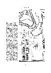
that it will show any prominent structure which will serve as a landmark. It may also incorporate a great deal of other material derived from terrestrial maps, but this is usually available more directly from the source documents. In tracing the history of Black Rock House, Sandringham, the date of the present house could be established with reasonable certainty from documentary sources as being between 1856 and 1858, possibly incorporating an earlier structure. However, the house is linked by a wall to an unusual enclosed courtyard. The house is low and built of timber, with brick gable ends, whereas the courtyard is very different, with high squared stone walls and a castellated top, together with skillion structures both within and without.
There seemed no reason to suppose that the courtyard was of the same period as the house, until it was found that H.L. Cox's Coastal Survey of 1862
3 clearly showed, albeit at a very small scale, a house linked to an open square, which could be nothing other than the courtyard in question. Further investigation showed that Cox in 1861 requested the Crown Lands Office to supply him with any accurate inland survey maps in their possession, so as to reduce the need for re-surveying. As there were few buildings in the area and, as yet, no municipality, it is likely that he received little more than the surveyed allotment boundaries. However, Cox also incorporated parts of an earlier coastal survey by Commander Ross, of 1856–59. Only one sheet of Ross's survey survives, and this does not show Black Rock House,
4 so we cannot be sure whether Cox was recycling Ross's earlier work, or drew the house from his own knowledge, but the episode certainly demonstrates the fact that Admiralty charts draw upon a variety of source materials .
A more recent case failed to produced a clear result, but it is nonetheless interesting. Lieutenant James Grant built what he called a ‘blockhouse’ on Churchill Island, Westernport Bay, in 1801. There has always been some doubt as to whether this was still standing at the time of the squatting occupation of the island in the 1850s, and as to where exactly it was located, though a contemporary map seems to show it near the south-east shore. A chart of 1842 shows no structure on Churchill Island,
5 but another of 1861 shows the ‘white house’, not in terms of its exact location, but in a sketch view of how it appeared from the sea — little more than three parallel horizontal lines, with a wavy belt below them, probably representing the shore.
6 We cannot be sure which building this was, but we can be sure that it was visible from a ship entering Westernport Bay at the eastern side, meaning that it was somewhere between the crown of the island and the eastern shore, and not in the location of the building shown on the map of 1801.
The Victoria Geological Survey began in the 1850s, spreading out from Melbourne and divided into ‘sheets’, each of which was actually produced in four sections, which are referred to as ‘quarter sheets’.
7 The concern of the survey was to record geological conditions generally, and also potentially valuable resources, varying from gold to brick earth. Although the presence of buildings was entirely incidental to this purpose, they are often shown as landmarks, especially in the case of hotels and public buildings. In addition, any penetration of the ground, such as a mine shaft, quarry or clay pit, is recorded with a commentary upon what is exposed,
20
21
and occasionally an outline of a building associated with the works, or one built from the stone or other material extracted.
Local government
Apart from the original towns of Melbourne and Geelong, the establishment of local government in Victoria dates from Andrew Clarke's
Municipal Corporations Act of 1855.
8 Some of the new municipalities prepared very detailed maps, mainly, no doubt, to assist in collecting rates, but probably also as a matter of municipal pride. A good example is the map of Richmond, though this is not held by the State Library. Every house and building is shown, not only in plan, but in colours indicating the principal building materials. These municipal maps were in turn used in compiling others, notably the one often referred to as ‘Kearney's’ (after the draftsman who signed it), which is held by the Library.
Kearney's plan is a strange mixture of data. In Richmond, as in Prahran, it records buildings as shown in the maps previously prepared by the municipalities. As it records the data reasonably accurately, it may save the researcher from the need to consult the originals, at least in the first instance. In Collingwood, where there seems to have been no municipal plan, there is non-specific hatching of blocks and an indication of certain landmark buildings, especially corner hotels. In parts of North Melbourne, North Fitzroy and St Kilda it shows street layouts which were being proposed at the time, but which never eventuated.
Water and sewerage
The establishment of a Board of Commissioners of Sewerage and Water Supply in 1853 did not, in the end, result in a sewerage system, but it did result in the construction of the Yan Yean Reservoir and the laying of a network of pipes throughout the built-up area. This required a survey showing the buildings to be connected, and for central Melbourne this is Thomas Bibb's Cadastral Map of Melbourne, of about 1854, generally known as ‘Bibb's Map’. It held at the PRO, and there is a copy at the Melbourne City Council.
The sewerage system was to be established only much later, under the
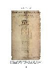
Melbourne and Metropolitan Board of Works Act, 1890. The new body, the MMBW, set about a vigorous program of surveying the area to be sewered, beginning in central Melbourne and working outwards. Most of the inner areas were surveyed during the 1890s, but further out some parts of Balwyn, for example, were not sewered until well after World War II, and by that time the survey work was far less detailed. The early surveys produced plans at 400 ft = 1 inch [1:4,800]; 160 ft = 1 inch [1:1920]; and 40 ft = 1 inch [1:480]. The 160-ft maps are the best starting point, for they are hatched to indicate the materials of the buildings, and even the separate parts
of each building [
see Fig. 10]. Their date is not always precise, because they were sometimes updated, though usually only with respect to changes between the time when the area was surveyed and when the sewerage connection was complete, perhaps a year or two. One of the many advantages of these plans is that they present a coherent picture of
22
all the buildings in a block or a street at a given date. This can be confidently correlated with the listings in a directory of the same date, and a researcher can use this firm base to work backwards or forwards through directories of earlier or later years without losing track of which property is which.
From these maps one can go to the 40-ft maps, which are far more detailed, not only in relation to the buildings themselves, where they indicate features such as cellars, but also their grounds. Fences, paths, fish ponds and fountains may be shown. Although this 40-ft series is much rarer, the State Library holds a fairly comprehensive set for the older parts of Melbourne. The next steps will take the researcher beyond the State Library. The MMBW issued a plan for each building showing the existing plumbing fixtures which were to be connected to the sewerage system, or otherwise were to be abolished. That became the basis of a file (the property file), to which would be added, whenever an owner sought a permit to do further work on the property, the new sewerage plan, often showing changes in the plan of the building, as well as the name of the then owner, and the agent (often the architect for the work) who made the application. These plans were often culled from the files in the later years of the MMBW. The files themselves passed to the corporatised bodies which succeeded the MMBW, and hence were in some cases destroyed, in some cases passed into private hands, and in some cases reached the PRO. One may also find at PRO the notes which were actually recorded by the surveyor on site during the survey, and these are even more detailed than the 40-ft plans.
Real estate
Real estate maps, meaning those prepared for the sale of property, may have been printed in numbers at the time, but usually survive today in a single copy from the files of the company concerned. The State Library holds principally the Vale and Houghton collections, but there are others, such as the Baillieu Allard collection held by Melbourne University Archives, covering the period 1887 to 1900, principally 1888. Occasional plans turn up in all sorts of other locations, such as the papers of the vendor or purchaser. The State Library also holds, in the Picture Collection, illustrations produced by the leading lithographers Troedel & Co., and many real estate advertisements and subdivision plans are to be found there as well.
These plans tend to be richer in detail where they are dealing with a subdivision rather than the sale of a single property, and especially so when it is going to auction. One can expect to find a reasonably accurate plan of the boundaries of the property and/or the subdivided lots. As well there will often be grossly distorted plans or birds-eye views showing the proximity of the property to central Melbourne, to the sea coast, to railway stations and other facilities. Often buildings on the property or on adjoining land are indicated, especially the houses of notable citizens, who are named. Sometimes, especially in the 1880s, one or more of the houses will be sketched, usually giving an exaggerated impression of its grandeur, for of course the purpose is to make the land and the area appear highly developed and desirable. Often these will be the only known illustrations of the houses in question. There may also be a panoramic
23
view of the site, or sketches, of varying degrees of accuracy, of other local landmarks or attractions — the pier, sea baths, town hall, railway station, and so on. However, as these structures are generally illustrated elsewhere — and more accurately — the real estate map is rarely going to be an important tool for researching them.
One of the earliest plans in this category is a broadside for the sale by auction of a cottage in Lonsdale Street on 17 July 1839 [
Fig. 11], held at the Library, not in the Map Collection but in the Picture Collection. It shows the allotment size, with a frontage of 33 feet [9.9 m] to Lonsdale Street and a depth of 94 feet [28.2 m]. The names of the property owners on either side (Gibson and Kavanagh) and behind (George Jones) appear. The plan of the house is shown integral with that of the site, and the scale is such that it is records all the relevant detail — a four-roomed cottage with the rooms named, and a detached outbuilding, unnamed but doubtless the privy. The drawing is signed by Chas F. Leroux, architect and surveyor, who was doubtless the designer of the building. Leroux is known to posterity as the government clerk of works at Melbourne, who was dismissed after only six months for excessive drinking, and died a year later at the age of thirty-four.
From the Vale Collection, an advertisement for Thomas Splatt's ‘Castlefield Estate’, Brighton, in 1856 [
Fig. 12], includes a location plan in relation to all the land from central Brighton southwards, between the coast and Arthur's Seat Road (the Nepean Highway); a plan of the estate itself in one lot; a plan of the proposed subdivision, including the existing house and garden; and a sketch view of Castlefield House, an extraordinary battlemented building which, but for this record, would be almost unknown to posterity.
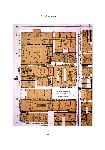
A sheet from 1884, advertising Bellevue Park in Northcote [
Fig. 13], is much more typical of the Boom period. It contains a plan of the subdivision, off Plenty Road, between James Street and Westbourne Grove. A number of existing houses are shown in block plan form on sites around the perimeter, many with the owner's name, while on Plenty Road there is a continuous row of buildings, probably shops, terminating with a corner building identified as the Peacock Inn. All this would be valuable enough in its own right, but there is also a panoramic view of the site with, in the left-hand foreground, an existing (or purportedly existing) two-storey Italianate house. Which it is has not yet been established.
A somewhat less usual Vale map of 1885 shows three allotments of land for sale in Sandridge Road (City Road) and Clarke Street, South Melbourne,
9 and, apart from showing an improbable concentration of shipping on the Yarra, to the north, the steam crane on the wharf, and Fulton's Foundry nearby in a sort of birds-eye perspective, it renders in isometric view the industrial and warehouse buildings near the allotments for sale, in City Road, Moray and Haig Streets, in sufficient detail to record the doors, windows and skylights, and in some cases the names on the facades.
Fire insurance
Fire insurance plans were prepared by fire insurance surveyors as a record of the existing conditions of structures and properties, so that an insurance company could
24
25
26
27
assess the risk posed by neighbouring buildings, as well as — after the event — the validity of the insurance claims which might be lodged. This means that they are very good in recording not just the plan and the number of storeys, but also the construction materials and the location of fire-protected and unprotected openings. It was necessary to keep them up to date as buildings were demolished or altered, and new ones constructed, and these data were inevitably useful to people other than insurance companies, for example real estate agents, who might also subscribe to the service.
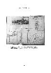
These requirements resulted in documents of a rather unusual character [
see Fig. 14]. A printed plan was issued, showing the buildings at a specified date. Then, as physical changes occurred, a representative of the publishers would visit the subscribers and amend the plans as necessary, usually by carefully pasting in the new or revised plan of the building, or a section of blank paper when it was demolished and the site left vacant. As these layers built up and became more cumbersome the company would finally find it worthwhile to print a complete new plan and start the whole process again. At one point, however, it seems that the Mahlstedt company printed a complete set of new plans for new subscribers only, but went on updating existing plans that it had already issued, so that there were two sets running in parallel until the next complete reprint took effect.
The implications of this are:
• | What is shown on a plan represents a situation at a date substantially later than the date of printing the base sheet. |
• | Unaltered base sheets are rarely found, though the State Library has some from 1923–24; and others might in theory be revealed by soaking off the accretions. |
• | The sheets as amended over time should represent the situation as it was shortly before the next printing. |
The individual changes are not dated, so the researcher can only assume that they occurred at some time after the printing of the base sheet and before the next reprinting. The date must then be clarified from other sources, such as building permits, rate books and directories.
The first such plans were by H.P. Dove in 1877, covering part of the central city in a fairly crude way. Dove's business continued in Sydney, but he withdrew from Melbourne, and the only known set of the Dove plans is in the library of Trinity College, University of Melbourne, microform copies of which are held at the State Library. The company which henceforward had a monopoly on such plans in Victoria began as Mahlstedt & Gee, and then became successively G. Mahlstedt, G. Mahlstedt & Son, and Mahlstedt's (Vic) Pty Ltd. For simplicity, these are all referred to as Mahlstedt plans. The first edition in 1888 covered the area between Lonsdale Street and the Yarra (later to be known as Section 1), 24 blocks on 24 pages — a block being taken as bounded by the principal streets, but including both sides of the ‘Little’ streets. This was reprinted without alteration to the base plan in 1901 and at later
28
29
dates. In 1910 Mahlstedts produced a second volume of plans covering Section 2, the part of the city north of Lonsdale Street. New editions of both sections were issued in 1923–24 and 1948, each time augmented by the addition of one or two small irregular blocks on the city fringe. Section 2 was last reprinted in 1962. In the meantime Mahlstedts at different dates issued plans for the industrialised area of South Melbourne (essentially from City Road to the Yarra), the heart of Geelong, and the heart of Ballarat.
The various editions of these Mahlstedt plans are held in different locations, including the Royal Historical Society of Victoria, the University of Melbourne Archives, the University of Melbourne Map Collection, and the collection of the present writer, but the State Library collection, by virtue of holding copies from other holdings, as well as originals, is the most comprehensive source.
Conclusion
There is no such thing as researching buildings from maps alone, and there is rarely such a thing as researching buildings using maps from only one collection. What we have seen is that maps are often a very important source for use in conjunction with the more usual written sources and architectural drawings. The Map Collection at the State Library is generally the best starting point for finding these maps, but the researcher will soon be led to other repositories — the Pictures and Manuscripts collections at the Library itself, the Royal Historical Society, University of Melbourne Archives, Lands Victoria, and, most of all, the Public Record Office. The information to be gained goes well beyond the simple location and form of the building, and beyond even its construction and appearance. It may include the design of the garden, views of the landscape, details of the neighbouring buildings and owners, and the relationship of the site to transport and other facilities.
Miles Lewis
30